![]()
Mt Alexander, Harcourt [ Images | Guide ] |
|
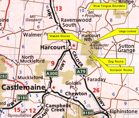
Below: A map of the area surrounding Mt Alexander. If you're driving up the Calder Hwy from Melbourne, take a right at Faraday, then left at the sign post to the Koala Park and Mt Alexander summit. About 1.2lm after the Koala Park, you'll find a small parking area on your right and Dog Rocks sign posted on your left.
For Wabbit Wocks, you'll need to drive into Harcourt, and hang a right heading towards Mt Alexander. Just before the road veers sharply left, take the dirt road (not pictured) straight on for about 500m, then left just as you enter the park itself. Find the oak trees down a ways, and head right to the picnic area. Park here, and do the steep walkin.
 |
|
|
|
Copyright Melway
Publishing 2002. Reproduced from Melway Edition 28 with permission. |
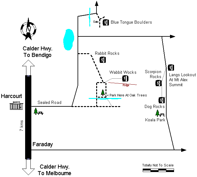
Below: Drawing of the approach to most Mt Alexander climbing locations. Dog Rocks is easy, you just turn off at Faraday, then follow the signs to the Koala Park, and find Dog Rocks beside the road a tad further on. Wabbit Wocks, however, requires driving into Harcourt, taking a right towards the mountain, continuing up a dirt road on the curve, then shortly heading left, across a little stream, right and parking at the Oak Trees. Then hike left up the steeply inclined 4wd track to the ridge line and following the faint walking path to the rocks.
Home | Guide | Gallery | Tech Tips | Articles | Reviews | Dictionary | Forum | Links | About | Search
Chockstone Photography | Landscape Photography Australia | Australian Landscape Photography
Please read the full disclaimer before using any information contained on these pages.
All text, images and video on this site are copyright. Unauthorised use is strictly prohibited.