![]()
Sponsored By
ROCK
HARDWARE
Chockstone Photography
Australian Landscape Prints |
 Chockstone Forum - Crag & Route Beta
Crag & Route Beta
| Area | Location | Sub Location | Crag | Links |
| VIC Buffalo | Gorge | South Side | Angels' Buttress | [ Gorge Guide ] |
| Author |
|
|||||
6:50:29 PM |
I've stayed in the hut repeatedly, and been caught repeatedly. The worst that has ever happened was a polite talking too, and agreeing to pay for a nights camping (but then we stayed the next night at Catani) so nothing really. On other occasions I have seen the ranger around sun down, explained my plans, they were non plussed. Mike is correct, you can see the route shortly after you pass Mushroom rock, from there on, the main thing you should have to worry about, navigation wise, is that you dont start up the bollocks looking variant start to the right. |
|||||
7:48:22 PM |
Getting caught bivvying in the sth side hut has different penalties depending on the following; * If it is a busy time for the Rangers, ie public holidays etc. (They are less tolerant then). * Who busts you, and how they are feeling on the day. * Your response to being busted. ~> In any event, it would be a fair grab, as they make their rules pretty well known... On 24/05/2013 gfdonc wrote: >Persons I may or may not have been associated with may have had all there >gear confiscated from the hut after a late-night bivvy coming off Ozymandias >some years ago. > >Same persons may or may not have been able to recover said gear from the >storage shed near Lake Catani without the ranger knowing about it. > >Same persons may or may not have subsequently been ejected from the park >after been caught in a traffic jam near the Chalet. > Interesting. A bit like the scenario of persons I may or may not have been associated with bivvying in the Chalet after a temporary retreat off the Nth Wall one time! |
|||||
4:30:00 PM |
Thanks all for the suggestions and directions - we found Angels easily. Some minor notes for anybody reading the thread in future: - the sign near the glider ramp reads "No Entry" (not "No Access). - path swings (hard! - 160 deg?) left about 50m after mushroom rock. Follow the cairns. We initially turned left too early and almost scrambled our way into trouble. - Fixed ropes (11 or 12mm static) were all well anchored at the top, and in very good condition. Thanks to whoever maintains them. - At the end of the first fixed line you hit a trickling rivulet. Can either follow the waterpath, or cross to burrow through some small trees before hitting the next fixed line. Weather was magnificent, and we had a fabulours four days in the Gorge. TR to hopefully follow. I'll put up waypoints once I've got them off my GPS. |
|||||
10:15:19 PM |
Awesome stuff Weekend Warrior. Is there much snow around the Plateau currently? |
|||||
1:02:35 AM |
Plateau is dry, weather is perfect for climbing - only brief afterthoughts of ice on the road in the early morning. Highly recommended if you can find time to get there before the next batch of cold weather | |||||
11:10:36 AM |
Did you happen to take down the way points while you were there? | |||||
6:45:38 PM |
All degrees 36'S 146'E. Remaining co-ordinates given with minutes only: Stone Hut: 43.336 49.310 "No Entry": 43.334 49.416 Enter Gulley: 43.345 49.480 Mushroom Rock: 43.326 49.805 RandomWaypoint: 43.305 49.477 Angels Viewpoint: 43.281 49.422 Angels Start: 43.233 49.353 Taken using a Garmin 60CSX, which defaults to WGS84. Accuracy subject to limited satellite view in restricted area. Caveats about using this data etc etc etc. |
|||||
7:04:33 PM |
Thanks David. | |||||
7:13:18 PM |
I've plotted the waypoints in GoogleMaps. It seems that the map is offset about about 150ft north of the actual points (note the difference between the picture of the road and the GPS measurement of the road.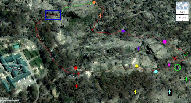 Arrows are where Google thinks the points are; circles are where I think the points actually lie. Red dots are where I think we walked, green dots are where I think we climbed, and the blue box is where I think Burston's Crevasse lies. In hind sight I think all the earlier pointers ("No Entry" - gulley - mushroom rock - fixed lines - recce Burston's beforehand) are infinitely more valuable than these waypoints. Enjoy! |
|||||
2:01:07 PM |
On 30/05/2013 WeekendWarrior wrote: >Arrows are where Google thinks the points are; circles are where I think >the points actually lie. (snip) >In hind sight I think all the earlier pointers ("No Entry" - gulley - >mushroom rock - fixed lines - recce Burston's beforehand) are infinitely >more valuable than these waypoints. > Thanks for saying that, as my initial thoughts on the matter (unspoken and old fashioned), are now vindicated... ;-) It is good to hear that you had a good time and I look forward to your Trip Report. |
|||||
3:54:51 PM |
>It is good to hear that you had a good time and I look forward to your Trip Report. Mmmmm, well, after almost 2 years i realize that we haven't written yet a proper trip report on this... so more kind of photo sharing this amazing week-end. |
|||||
9:48:18 AM |
On 4/02/2015 clusterfck wrote: >>It is good to hear that you had a good time and I look forward to your >Trip Report. > >Mmmmm, well, after almost 2 years i realize that we haven't written yet >a proper trip report on this... so more kind of photosharing this amazing week-end. I very much enjoyed the link, so thanks for sharing it. I re-read your Ozymandias trip report (I never tire of reading of others experiences on it!), and also read your other Trip Reports for; The Dragon’s Horns on Tioman Island, Malaysia, Part6: Trip Report, Damai Sentosa 280m / 6c+ (Heavy duty on your ropes!) and, El Capitan – Yosemite, USA, Part0: Trip Report, Lurking Fear VI 5.6 C2+ (Would be interested in the full story behind that!) Well done. |
|||||
1:55:28 PM |
Thanks Rod ! Mount Buffalo is definitely my favorite place in Ozy. Come and visit us, Tioman can really provide you with some funky experiences ! > El Capitan – Yosemite, USA, Part0: Trip Report, Lurking Fear VI 5.6 C2+ (Would be interested in the full story behind that!) What about a beer next time we in the Alps :) Cheers |
| There are 33 messages in this topic. |
Home | Guide | Gallery | Tech Tips | Articles | Reviews | Dictionary | Forum | Links | About | Search
Chockstone Photography | Landscape Photography Australia | Australian Landscape Photography | Landscape Photos Australia
Please read the full disclaimer before using any information contained on these pages.
Australian Panoramic |
Australian Coast |
Australian Mountains |
Australian Countryside |
Australian Waterfalls |
Australian Lakes |
Australian Cities |
Australian Macro |
Australian Wildlife
Landscape Photo |
Landscape Photography |
Landscape Photography Australia |
Fine Art Photography |
Wilderness Photography |
Nature Photo |
Australian Landscape Photo |
Stock Photography Australia |
Landscape Photos |
Panoramic Photos |
Panoramic Photography Australia |
Australian Landscape Photography |
High Country Mountain Huts |
Mothers Day Gifts |
Gifts for Mothers Day |
Mothers Day Gift Ideas |
Ideas for Mothers Day |
Wedding Gift Ideas |
Christmas Gift Ideas |
Fathers Day Gifts |
Gifts for Fathers Day |
Fathers Day Gift Ideas |
Ideas for Fathers Day |
Landscape Prints |
Landscape Poster |
Limited Edition Prints |
Panoramic Photo |
Buy Posters |
Poster Prints