![]()
Sponsored By
ROCK
HARDWARE
Chockstone Photography
Australian Landscape Prints |
 Chockstone Forum - General Discussion
General Climbing Discussion
| Author |
|
|||
10:06:20 PM |
Guys Dont know if this is of any interest to you but in 2002 I did a walk across the Sarawaged Range which forms the spine of the Huon Penisula to the immediate south of the Finistere range. This included the summit of Mt Sarawaged (4040m), or Sarawaket as you earlier referred to it. I've got a couple of photos of this range including one from the summit N to Mt Bangieta (4,120m) which is all really the southern continuation of the Finistere Range.None of what I saw is really what I'd term "climbing" country, though there are some incredible limestone cliffs. Anywhere on those cliffs with a ledge is usually densely clogged with vegetation so I'm not sure if the climbing prospects are what I'd call attractive. All in all it's some spectacular alpine karst country at altitude (nearly all above 3600m), lots of sinkholes with rivers disappearing into them etc, with open rolling grassy plains & fern trees. Trouble is I've had no luck loading the images onto the server, but if you want a look at a couple of the more general shots to get an idea of the country drop us a line with your email address & I'll send them to you. Also this alpine area covers tens of square kilometres & offers lots options for open walking & exploring (glacial lakes etc) & probably offers a much more straight forward alternative for exploration if you're interested in something less commiting. Regards Tangles |
|||
11:27:06 PM |
Finally heres some of those pics. Firstly Mt. Sarawaged 4040m, an easy walk, scramble to the summit.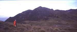 From the summit of Mt Sarawaged north to Mt. Bangietta 4120m, about 8km away. The peak is the high point to the immediate right of the distinct notch in the skyline. 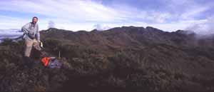 This view gives an ideas of the southern face of the Sarawaged Massif. It extends about 15-20 km like this, nearly all above 3500-3700m. 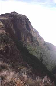 Rugged country & hard yakka to get into. Rugged country & hard yakka to get into.
|
| There are 42 messages in this topic. |
Home | Guide | Gallery | Tech Tips | Articles | Reviews | Dictionary | Forum | Links | About | Search
Chockstone Photography | Landscape Photography Australia | Australian Landscape Photography | Landscape Photos Australia
Please read the full disclaimer before using any information contained on these pages.
Australian Panoramic |
Australian Coast |
Australian Mountains |
Australian Countryside |
Australian Waterfalls |
Australian Lakes |
Australian Cities |
Australian Macro |
Australian Wildlife
Landscape Photo |
Landscape Photography |
Landscape Photography Australia |
Fine Art Photography |
Wilderness Photography |
Nature Photo |
Australian Landscape Photo |
Stock Photography Australia |
Landscape Photos |
Panoramic Photos |
Panoramic Photography Australia |
Australian Landscape Photography |
High Country Mountain Huts |
Mothers Day Gifts |
Gifts for Mothers Day |
Mothers Day Gift Ideas |
Ideas for Mothers Day |
Wedding Gift Ideas |
Christmas Gift Ideas |
Fathers Day Gifts |
Gifts for Fathers Day |
Fathers Day Gift Ideas |
Ideas for Fathers Day |
Landscape Prints |
Landscape Poster |
Limited Edition Prints |
Panoramic Photo |
Buy Posters |
Poster Prints