![]()
Sponsored By
ROCK
HARDWARE
Chockstone Photography
Australian Landscape Prints |
 Chockstone Forum - General Discussion
General Climbing Discussion
| Author |
|
|||||
2:52:57 PM |
I did some Google Earth detective work- the dramatic photo is not the Muline/Red Rocks area of the Victoria Range, it seems to be further south, with Mountain Lion crag dead centre of frame. The photo is taken from the Henty Highway at about Moralla. http://www.thecrag.com/climbing/australia/grampians/mountain-lion 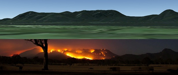
|
|||||
9:58:45 AM |
Any update? Did they get much rain? my google search didn't seem to find much | |||||
10:02:12 AM |
We got 0.6mm in Horsham and Stawell last night and Hamilton got nothing. The most recent map from the DSE: GRAMPIANS - Victoria Valley Complex 25th Feb PM.pdf |
|||||
10:02:46 PM |
From latest reports the Victoria Valley Complex Fire has now been contained. You can read the media release and the latest newsletter here. http://cliffcare.org.au/2013/02/27/grampians-victoria-valley-fire-is-now-contained-update/ cheers, Tracey |
|||||
10:40:13 AM |
Hi Tracy. Based on past experience, how long do think think it might be until the Victoria Range is open again, particularly areas such as Buandik? | |||||
3:30:35 PM |
Is this a joke? 2-3 years? | |||||
3:46:07 PM |
On 1/03/2013 Dave.k wrote: >Hi Tracy. Based on past experience, how long do think think it might be >until the Victoria Range is open again, particularly areas such as Buandik? Hi Dave, I'm not even going to hazard a guess on this one. When an area will open is dependant on so many things and at this stage the areas haven't been properly assessed. The fire is still going in some parts. While the fire might go through an area, sometimes, it will burn longer and hotter in one section and then quickly burn over another giving you totally different outcomes for the areas recovery. And then again you might even have a pocket where it completely skips. I know some early aerial assessment has started and be sure that I will fill you in as soon as I have some useful information. I know everyone is really eager to know but I would plan your climbing trips around other areas towards the north. That way your plans won't be mucked up..Fire is still going in some sections so staff are still involved in that. >On 1/3/2013 James wrote: >Is this a joke? 2-3 years? Huh?? cheers, Tracey |
|||||
3:54:31 PM |
sorry was referencing the Rosea/Bundaleer closures after those fires. That area was closed for a looooong time. | |||||
4:39:50 PM |
On 1/03/2013 james wrote: >sorry was referencing the Rosea/Bundaleer closures after those fires. >That area was closed for a looooong time. From your post I figure that you would like the areas open as soon as the fire danger has passed. Unfortunately the damage caused by fire is complex and disturbance of the recovery process occurs in many ways. These can lead to prolonged recovery, significantly increased and distabilizing errosion and significantly greater introduction of pest plant species. Often people have the thought 'but its only me, how much damage can I do', but there are often hundreds of other people thinking the same thing. Assessment of the damage and suitable recovery need to be made by people with the appropriate experience and knowledge and really should be left to them. If an area requires years to recover, so be it. Don't be too precious, go somewhere else. |
|||||
5:44:39 PM |
Come to the Blue Mountains, there are presently no major fires. | |||||
5:55:10 PM |
On 1/03/2013 access t wrote: >Hi Dave, > >I'm not even going to hazard a guess on this one. When an area will open >is dependant on so many things and at this stage the areas haven't been >properly assessed. The fire is still going in some parts. While the fire >might go through an area, sometimes, it will burn longer and hotter in >one section and then quickly burn over another giving you totally different >outcomes for the areas recovery. And then again you might even have a pocket >where it completely skips. I know some early aerial assessment has started >and be sure that I will fill you in as soon as I have some useful information. >I know everyone is really eager to know but I would plan your climbing >trips around other areas towards the north. That way your plans won't be >mucked up..Fire is still going in some sections so staff are still involved >in that. Thanks Tracy, and many thanks for keeping us up to date. Cheers, Dave |
|||||
3:11:38 AM |
On 1/03/2013 The good Dr wrote: >On 1/03/2013 james wrote: >>sorry was referencing the Rosea/Bundaleer closures after those fires. > >>That area was closed for a looooong time. > >From your post I figure that you would like the areas open as soon as >the fire danger has passed. Unfortunately the damage caused by fire is >complex and disturbance of the recovery process occurs in many ways. These >can lead to prolonged recovery, significantly increased and distabilizing >errosion and significantly greater introduction of pest plant species. >Often people have the thought 'but its only me, how much damage can I do', >but there are often hundreds of other people thinking the same thing. > >Assessment of the damage and suitable recovery need to be made by people >with the appropriate experience and knowledge and really should be left >to them. If an area requires years to recover, so be it. Don't be too precious, >go somewhere else. I actually thought dave.k was hoping it would re-open soon, which I thought was pretty funny given how long other areas stayed closed post fires. Maybe he wasn't round when the last couple fires rolled through? BTW not being precious - I don't care either way myself. Haven't been & won't be climbing anywhere near the gramps anytime soon. |
|||||
9:29:19 PM |
Parks' previous excuse for delays re-opening tracks after fire has been more to do with public safety, ie liability, than ecology. That makes it an issue of resources & bureaucratic caution, which is harder to accept. | |||||
9:09:58 AM |
Is there some better explanation of why Rosea was closed *again*? We were in Halls Gap (& south of there) over the weekend, not a whiff of smoke. |
|||||
9:48:19 AM |
On 4/03/2013 gfdonc wrote: >Is there some better explanation of why Rosea was closed *again*? >We were in Halls Gap (& south of there) over the weekend, not a whiff >of smoke. > This was a big fire that was going all over the place depending on the wind. In the circumstances it's quite reasonable to set a clear exclusion area. Rosea and Bundaleer just happen to sit inside. I'm no fan of keeping areas closed but given that this week is going to get hot again it's probably prudent to keep the full area shut for now in case it flares again. That there's no smoke doesn't mean that everything is out. I remarked on the lack of smoke on 15/2 shortly before it really took off. It's probably not really safe until there's a decent rain. A quick glance at the map of the fire area shows that it's not all that far from the Vic Range to Rosea. An outbreak in the wrong spot with a strong south-westerly could cover the ground overnight. I'd hope that by Easter Rosea and Bundaleer could be open again but it's probably too soon to start hassling Parks about it now. I imagine the response would be something like "Bugger off. Have you any idea what has been going on in the last 3 weeks?" |
|||||
10:02:37 AM |
On 4/03/2013 kieranl wrote: >I'd hope that by Easter Rosea and Bundaleer could be open again but it's >probably too soon to start hassling Parks about it now. I imagine the response >would be something like "Bugger off. Have you any idea what has been going >on in the last 3 weeks?" Completely agree. While there may be legitimate reasons to complain for year or more closures simply due to fear of liability there does not seem much justification to complain about short term closures due to fires. |
|||||
5:32:37 PM |
There should be some news early next week on the fire-affected areas. Parks are holding a briefing in Halls Gap on Tuesday next week. This from Zoe Wilkinson of Parks Vic : "The plan is to give you all a briefing on how the fire situation unfolded, and what our best information is to date on climbing areas affected and how the fire severity has varied over the Vic Range. We’ve got quite a few photos from helicopters as well as information from people out on the ground. We can talk about some of the concerns from PV regarding road damage, tree risk, soil stability and weed invasion potential etc. Then we have a good discussion on how best to manage all this and get a phased re-opening of areas and how to communicate all of this." Unfortunately I can't get there because it's my first day back at work but I understand Tracey Skinner and Steve Monks and possibly some others will be there. I expect Tracey will give us a report soon after. Zoe is also going to pass some information back to me. Full marks to Parks for getting onto this so soon after the event. By mid-next week we will at least have some real information on access rather than just speculation. |
|||||
8:04:24 AM |
Thanks for the update Kieran, sounds like they're fairly well organised at the moment. | |||||
12:13:28 PM |
Latest map from Parks (arrived 9:24am today) showing the currently closed areas, so looks like Rosea and Bundaleer are accessible this weekend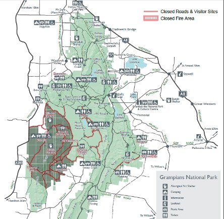 * post-edit * This map is more up-to-date than that on the Parks website which is from 1st March |
|||||
9:03:22 PM |
I drove down the Henty to Penshurst today. The northern part of the range looks pretty toasted. Once you get to the Buandik turn off, you reach where the fire burned up to the road and over. You can see clear to the base of the range and it's pretty well all black. That flood plain area that had all the scrub is all ash and black sticks though it looks like the occasional grass tree survived. That continues until you get to the Whoolpooer sign though less severe in a few places. |
| There are 97 messages in this topic. |
Home | Guide | Gallery | Tech Tips | Articles | Reviews | Dictionary | Forum | Links | About | Search
Chockstone Photography | Landscape Photography Australia | Australian Landscape Photography | Landscape Photos Australia
Please read the full disclaimer before using any information contained on these pages.
Australian Panoramic |
Australian Coast |
Australian Mountains |
Australian Countryside |
Australian Waterfalls |
Australian Lakes |
Australian Cities |
Australian Macro |
Australian Wildlife
Landscape Photo |
Landscape Photography |
Landscape Photography Australia |
Fine Art Photography |
Wilderness Photography |
Nature Photo |
Australian Landscape Photo |
Stock Photography Australia |
Landscape Photos |
Panoramic Photos |
Panoramic Photography Australia |
Australian Landscape Photography |
High Country Mountain Huts |
Mothers Day Gifts |
Gifts for Mothers Day |
Mothers Day Gift Ideas |
Ideas for Mothers Day |
Wedding Gift Ideas |
Christmas Gift Ideas |
Fathers Day Gifts |
Gifts for Fathers Day |
Fathers Day Gift Ideas |
Ideas for Fathers Day |
Landscape Prints |
Landscape Poster |
Limited Edition Prints |
Panoramic Photo |
Buy Posters |
Poster Prints