![]()
Sponsored By
ROCK
HARDWARE
Chockstone Photography
Australian Landscape Prints |
 Chockstone Forum - General Discussion
General Climbing Discussion
| Author |
|
|||||
10:59:30 PM |
Bugger you Vics are copping it big time. CFA just tweeted @CFA_Updates: RT @victoriapolice: Police urging drivers take care on Western Hwy btwn Dadswell Brdge & Horsham. Extreme weather making driving hazardous. Was hoping to come over soon to introduce my daughter to the beautiful Gramps - fingers crossed you all dodge any drama. |
|||||
8:44:14 AM |
No sign of smoke over Grampians this morning. Lots if little fires still showing up on DSE site though. Hopefully with the rain overnight and attention this morning these will be out shortly. | |||||
9:29:32 PM |
Stand by we had a shedload of thunderstorm activity come through Adelaide this evening | |||||
9:55:29 PM |
Yeah another lot just went through Horsham too. | |||||
9:57:24 PM |
And this advice through from Parks about an hour ago. Still lots of fires about and no doubt more to come overnight.. Grampians Complex fires Update – 15 February 2013 Please find the attached newsletter to provide you with further information on the fire situation in the Grampians National Park. Please note the following closures in the park: • Bullawin Road is closed between Glenelg River Road and Victoria Point Road • Jensens Road is closed between Glenelg River Road and Back Road • Sheeps Hills Walking Track • Major Mitchell Plateau Track • Jimmys Creek Track • Mt William Road • Mitchell Plateau Overnight Walk Parks Victoria and DSE advises visitors to the park not to go hiking or overnight hiking in remote areas including the Victoria Range and the Mount Difficult Range. Visitors should also stay away from the southern end of the Victoria Range and Victoria Valley. For further information on these fires or other fires in Victoria check for the latest warnings and advice messages at either www.dse.vic.gov.au/fires or www.cfa.vic.gov.au Or please contact the Victorian Bushfire Information Line (VBIL) on freecall 1800 240 667. Callers who are deaf, hard of hearing, or have a speech/communication impairment may call textphone/telewriter (TTY) on 1800 122 969. |
|||||
9:18:43 AM |
Bucketload of fires over weekend. Luckily no real impact on climbing areas. Red Rock road fire on Saturday night was contained quickly which is good - could have really made a mess.. Jensens Rd fire flared up again and is now out of control and burning towards farmland however there's a southerly wind change tonight that might send it back in to bush. Going to be a bad day today with a risk of some of the smaller fires flaring up. |
|||||
9:33:33 AM |
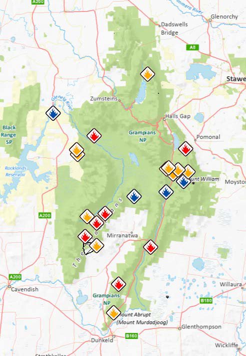 This is the firemap from DSE yesterday though nothing much has changed except that the Jensens Rd fire is now a threat. Red means going, Yellow means contained, Blue means controlled. Today I'm worried about the little fire that's been quietly going in the Victoria Gap flaring up and burning southward. And the Red Rock Rd fire which is only contained, starting up again and blowing into the rough country south and west. |
|||||
10:07:30 AM |
Just in : All areas of the Victoria Valley and Victoria Range Areas are CLOSED - Parks Victoria are advising visitors to the Grampians National Park that the Victoria Valley (area South of Mount Victory Road) and Victoria Range (West of the Serra Range) are closed. Park Road Closures: • Victoria Valley Road at intersection of the Grampians Tourist Road to the intersection of Victoria Point Road (through to Mirranatwa Gap) • Greens Creek Road • Red Hill Road • Bullawin Road is closed between Glenelg River Road and Victoria Point Road • Jensens Road is closed between Glenelg River Road and Back Road • All entry roads into the park from the Henty Highway including Glenelg River Road, Lodge Road and Billywing Road Visitor Site and Walking Track Closures: • Strachans Campground • Buandik Campground • Boreang Campground • Ingleton Springs Picnic area • Red Rock Picnic area • Manja Shelter • Billimina Shelter • Chimney Pots • All climbing areas and tracks in the Victoria Range and Red Rock area |
|||||
9:01:53 AM |
Someone from Strathkellar uploaded a picture of the Vic Range fires last night: |
|||||
10:31:12 AM |
Victoria Valley Complex Overview http://osom.dse.vic.gov.au/public/osom/attachments/1327332022/20130219_0500_Grampians_VictoriaValley_Overview.pdf Provides a very solid overview of the current situation. |
|||||
11:26:15 AM |
My reading of this is that everything from Bundaleer Northwards should be okay for the weekend, if nothing else changes? | |||||
12:20:12 PM |
Looking at the Parks web site, Bundaleer and Rosea may be included in the current closed area. Here's a link to their map : http://parkweb.vic.gov.au/__data/assets/pdf_file/0008/572561/Grampians-fire-closures-map.pdf The line is a little bit wonky but I would guess that Bundaleer and Rosea are included. But I would err on the side of caution and assume that they're a no-go zone this weekend unless things improve. That's what I did with the northern Vic range last Saturday even though it wasn't closed at the time. |
|||||
2:18:31 PM |
Hopefully things will improve further. Here's the latest, Grampians Tourist road is re-opened, sent at 2:11pm As fire activity at the Cassidy Gap fire has subsided the Grampians Tourist Road from Halls Gap to Dunkeld is now OPEN. Kind Regards Prue Daley Tourism & Communication Grampians District Parks Victoria |
|||||
2:36:13 PM |
Smoke in Horsham is pretty bad and we're well over 50 km north of the fire. | |||||
3:02:10 PM |
I think I could see this fire glowing/reflecting off the clouds as I drove home from your place last night. | |||||
9:50:35 PM |
Cheers for the info Kieran, looks like further North is the go. | |||||
10:04:51 PM |
Just looked at my emails for first time this evening and the fire now appears well back into the Vic Range around Strachans and Chimney Pot gap. This from the 6:30 report : "Southerly winds overnight and throughout the day have pushed the fire across the Victoria Range. Some spotting may be occurring. Planned burns completed last autumn along the Harrop Track within the Grampians National Park are expected to assist with controlling the spread of the fire to the west". Good chance of a lot of climbing areas on west side being burnt in the next few days. The closure map on the Grampians NP website has now been updated and Rosea and Bundaleer are clearly within the closed area. Wonderland Range isn't in the closed area. |
|||||
8:50:53 AM |
Right through the Vic Range. Spotted into the pine plantations to west overnight and now about 3 km from Glenisla homestead. | |||||
9:44:05 AM |
There's some pics in the paper: http://www.mailtimes.com.au/story/1308717/latest-grampians-fire-updates/?src=chockstone | |||||
11:59:05 AM |
Aaaargh, are you guys in for some rain later today? I really hope it doesn't burn out all the good crags (and they end up being off limits for the whole climbing season) |
| There are 97 messages in this topic. |
Home | Guide | Gallery | Tech Tips | Articles | Reviews | Dictionary | Forum | Links | About | Search
Chockstone Photography | Landscape Photography Australia | Australian Landscape Photography | Landscape Photos Australia
Please read the full disclaimer before using any information contained on these pages.
Australian Panoramic |
Australian Coast |
Australian Mountains |
Australian Countryside |
Australian Waterfalls |
Australian Lakes |
Australian Cities |
Australian Macro |
Australian Wildlife
Landscape Photo |
Landscape Photography |
Landscape Photography Australia |
Fine Art Photography |
Wilderness Photography |
Nature Photo |
Australian Landscape Photo |
Stock Photography Australia |
Landscape Photos |
Panoramic Photos |
Panoramic Photography Australia |
Australian Landscape Photography |
High Country Mountain Huts |
Mothers Day Gifts |
Gifts for Mothers Day |
Mothers Day Gift Ideas |
Ideas for Mothers Day |
Wedding Gift Ideas |
Christmas Gift Ideas |
Fathers Day Gifts |
Gifts for Fathers Day |
Fathers Day Gift Ideas |
Ideas for Fathers Day |
Landscape Prints |
Landscape Poster |
Limited Edition Prints |
Panoramic Photo |
Buy Posters |
Poster Prints