![]()
Sponsored By
ROCK
HARDWARE
Chockstone Photography
Australian Landscape Prints |
 Chockstone Forum - Crag & Route Beta
Crag & Route Beta
| Area | Location | Sub Location | Crag | Links |
| VIC Buffalo | Eurobin Falls | (General) | (General) | [ Eurobin Falls Guide ] |
| Author |
|
|||||
12:43:59 PM |
The new guide indicates there is a rap station at the top of the falls, on the left side (the photo topo shows it at the top of a grade 12 pitch, just underneath a big hanging block). We were up there yesterday and couldn't find anything. Has anyone seen it? I would be interested in putting one there because the walkdown is about 40 minutes of bushbashing, some of it through very thick fernage. | |||||
1:19:01 PM |
assume the new guide isn't always correct. But I vaguely remember one Adding/replacing rap stations would be excellent. |
|||||
1:19:18 PM |
Hi, yes there is a rap near the top of Eurobin Fall (but it's in very poor condition and needs replacing badly!). I'll try and find you a photo showing it's location. It might not be where you think it is however (from memory it's not at the very top of the cliff but on a ledge at about 3/4 height). There are actually two raps which take you to the ground. Both are some of the worst bolts I've ever rapped off (with the exception of the ones on top of "pocket full of dreams" at Muline in the Grampians). They are mild steel carrots (the bash in kind) which after being in running water for about 20-30 years are looking very less than ideal! there is also nothing around which you can back them up with. Someone needs to replace them!!! Regards, Josef |
|||||
2:06:32 PM |
I was up there before that topo came out, so we didn't expect a rap anchor up there and certainly didn't see one. But we also didn't go within 15m of that capping block so its entirely possible there's one there The walk down was fine though, only about 10-15 minutes and nothing all that thick - which side of the crag did you descend? |
|||||
9:09:39 PM |
Hi, here is where the rap is (not quite at the top of the cliff): 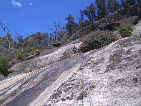 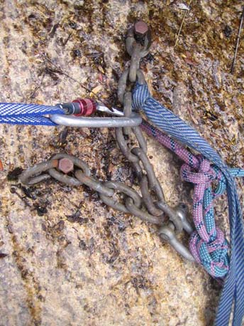 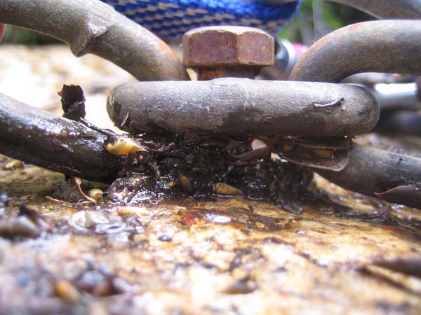 and the one below... looking at it from the rap above... 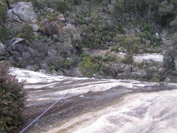 and up close - YUK! 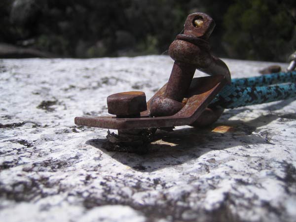
|
|||||
9:38:54 PM |
Hey Joe you were nowhere near the top - it's another pitch and a half (~75m) from there to the top. See the blue circle in this pic. Green circle is Llafnwod's rap anchor atop p1, red circle is where the guidebook topo says the top anchors should be 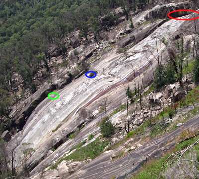
|
|||||
9:49:43 PM |
haha looking at your photos joe i think maybe the walkdown was the better option! The capping block i'm talking about is in the very top right of your first photo, and it's probably about 80m higher than the ledge that guy is standing on. The advantage of having a rap station where it's marked in the guide is that you can protect the right-facing corner that leads to it (as opposed to soloing an unprotected polished slab). That pitch is marked in the guide as the 3rd pitch of Llfanwod. It looks like it would be 4 raps to get all the way down from the very top. There's a really nice double waterfall and swimming pool right at the very top (marked "The Bath" in the guide). I would guess that not many people have been there because it seems many people rap off Mother Of Pearl from where you did. We walked down on the L (looking out) as the guide suggested. |
|||||
12:14:18 PM |
rapped off that stuff a few years ago. the topmost anchor is down a little from the top "walking ledge", and the mid-point rap is very manky. never even thought of walking down. if i was in Oz, i'd donate some crust for some new hardware. |
|||||
9:58:37 PM |
On 22/12/2008 gordoste wrote: >haha looking at your photos joe i think maybe the walkdown was the better >option! The capping block i'm talking about is in the very top right of >your first photo, and it's probably about 80m higher than the ledge that >guy is standing on. >The advantage of having a rap station where it's marked in the guide is >that you can protect the right-facing corner that leads to it (as opposed >to soloing an unprotected polished slab). That pitch is marked in the guide >as the 3rd pitch of Llfanwod. >It looks like it would be 4 raps to get all the way down from the very >top. There's a really nice double waterfall and swimming pool right at >the very top (marked "The Bath" in the guide). I would guess that not many >people have been there because it seems many people rap off Mother Of Pearl >from where you did. >We walked down on the L (looking out) as the guide suggested. my legs are still recovering from that bloody walk out!!!! if i was to climb it again i'd take an inflatable tube and ride the falls to a death less painfull!!! |
|||||
7:27:11 AM |
Thanks Will & Steve for the clarification. Sounds like we should sink some quality stainless and sort this out. |
|||||
10:02:01 PM |
If you get to it before i do, i'd suggest putting the top anchor on the actual capping block instead of on the slab. That way the bolts would be protected from the weather and also pulling the rope would be a lot easier than if they're on the slab, which rolls over until you can walk around on it in hiking boots. | |||||
2:27:34 PM |
Shiltz and I did the route Mother Of Pearl into a combo of Llafnwod P2 then back into P5 of MOP last weekend. We did it as 4 pitches being P1 (G14) as 1½ pitches (60m rope) of MOP, then the (unprotected G12) section of MOP being a 35m transition pitch from the corner more or less directly up/trending R, to the abseil station half way up P2 of Llafnwod; then another short pitch of 30m (unprotected), straight up (crux G18 for a few moves, direct start P3 Llafnwod, & rig the belay to minimise a FF2), to belay directly above at base of P5 of MoP; and our last pitch (G14, 45m) the corner to belay off a manky tree (and a large cam significantly off to the side), both under the capping block. Comments. There was enough flow in Eurobin Ck that we did not want to cross the water & slime covered secondary stream at top, let alone the main stream to bush-bash back down on the left looking out. The right hand side was feasible for an abseil but the regrowth likely snarling ropes deterred us. Going further right (looking out), would also be a feasible bush-bash, but that is not what we were there for. There is no abseil station at the 'top', so we abseiled off the manky tree. It is a Tea-tree style bush with roots embedded in slime under rotting rocks... We kept our b/u large cam in for the first person off, but last removed it. Given the size of the tree and the insecure root system, I don't expect it to last long, particularly if we get another drought. Our 60m ropes came up about 5 maybe 7m short of the guidebook marked Llafnwod abseil station, so we used a good secure multi-trunked fig-type tree about 20m higher, located in the corner system. At this tree we found an abandoned 'abseil sling', backed it up (2nd removed b/u), then continued to the DBB abseil anchor. A further two abseils (used a lower bolted belay), got us off back at the start of MOP. In my opinion the climb is well named for the last pitch(!), and it is a good adventure day out with great views and ambience. There is no truth to the rumour that any blood found on holds immediately off the abseil station/direct start P3 Llafnwod is mine!! ;-) I agree* with On 26/12/2008 gordoste wrote: >i'd suggest putting the top anchor on the actual capping block instead of on the slab. That way the bolts would be protected from the weather and also pulling the rope would be a lot easier than if they're on the slab, which rolls over until you can walk around on it in hiking boots. ~> of suggesting an abseil station on the vertical capping block, though I wouldn't want to cross the slime-stream (no matter the footwear) that we found; as that is an unintentional shortcut to the bottom... (*Note: As I reported above, double 60m ropes from here, won't get you back to the guidebook marked Llafnwod abseil station.) |
|||||
3:16:25 PM |
So that's what we did... I hadn't got back to my guidebook to try and work it out yet. In Will's picture I guess the green circle is the DBB at the end of our P1 and the blue circle is the DBB where we finished P2. The slab directly above that to the solid bushes (with the abandoned abseil sling) at the base of the final corner is our P3. And our P4 ended at the red circle. I'd say P1 was about 55m. P2 about 30m. P3 about 25m. And P4 about 45m. So a rap point in the red circle would not get you back to the blue circle unless you had two 70m ropes. Nice bit of thread escavation M9. |
|||||
5:10:05 PM |
Good on you Rod MOP is one of the nicer routes at Buffalo! Ive done it 3-4 times over the years and im sure I went down the jungle on the left to get off...no raps | |||||
8:56:05 PM |
On 16/12/2014 jrc wrote: >Good on you Rod MOP is one of the nicer routes at Buffalo! Ive done it >3-4 times over the years and im sure I went down the jungle on the left >to get off...no raps We swung leads. Shiltz was first and third, so he got the G18 bit, and deserves credit for dragging me up it. Heh, heh, heh. |
|||||
2:42:04 PM |
Ok folks. 3 summers ago we put a rap station on the overlap immediately above the old rusty one indicated in Blue on Wills diagram. There is a new variant finish to llafnwod that heads right off the belay indicated in green and leads directly to the belay in blue.. Probably 14ish, 3bolts 50m. When its dry its sublime, when its wet its just slime. Then there is a pitch that heads straight above the new belay and up to the anchors in red. Geoff Gledhill showed me the way down from the top and as I indicated it the guide its in the corner on the left side beneath the Headwall /Block thing. We really should have gotten in and replaced them too but the wall was baking hot by 10am and we bailed out. From the blue rap we went to the top anchors of under glass in the middle of the wall, although the new rap on top P1 of llafnwod are a way better bet. If I get back up there I'll do the top belay too. Anyone know what happened to the first pitches of the routes on Mackeys Lookout. It would appear that over winter the whole 'stepped overhang' thing has exfoliated in a very big way! Is it a new route if you are climbing brand new features where a route previously existed on rock that has now disappeared? |
|||||
3:31:36 PM |
Yes. Or an eliminate, in a geophysical sense. | |||||
4:57:13 PM |
On 18/12/2014 tradgic wrote: >Ok folks. 3 summers ago we put a rap station on the overlap immediately >above the old rusty one indicated in Blue on Wills diagram. Yep, these must be the ones we used to belay at the top of our P2 and then to descend. Thanks for putting them in! >There is a new variant finish to llafnwod that heads right off the belay indicated >in green and leads directly to the belay in blue.. Probably 14ish, 3bolts >50m. When its dry its sublime, when its wet its just slime. We didn't see these bolts on the way up or on the way down. M9 led the second pitch (from the green circle to the blue circle) without any runners. >Then there is a pitch that heads straight above the new belay and up to the anchors >in red. For our P3 I led straight up from the blue circle belay but only as far as the next break, at the base of the final corner. There were no runners on this pitch either, none that I found anyway. It was a hard start from the belay requiring some "team tactics". So I kept P3 short so that rope stretch wouldn't cause M9 to hit the slab below if he fell on the initial moves. I'm glad I didn't press on as I would have run out of rope mid-way up the final corner anyway. P4 was really nice the way M9 lead it, although the tree we had to climb through towards the top made it slightly less pleasant than it could have been. >Geoff Gledhill showed me the way down from the top and as I indicated >it the guide its in the corner on the left side beneath the Headwall /Block >thing. Do you mean the left side of the red circle? How did you get to there from the top? Or did I misunderstand? >We really should have gotten in and replaced them too but the wall >was baking hot by 10am and we bailed out. I imagine that wall would be truly awful on a hot day. Better to just go for a swim in the creek. >From the blue rap we went to >the top anchors of under glass in the middle of the wall, although the >new rap on top P1 of llafnwod are a way better bet. If I get back up there >I'll do the top belay too. > >Anyone know what happened to the first pitches of the routes on Mackeys >Lookout. It would appear that over winter the whole 'stepped overhang' >thing has exfoliated in a very big way! > >Is it a new route if you are climbing brand new features where a route >previously existed on rock that has now disappeared? |
|||||
8:55:15 AM |
On 18/12/2014 tradgic wrote: >Is it a new route if you are climbing brand new features where a route >previously existed on rock that has now disappeared? Yes. I understand that in some parts of Britain such events are eagerly anticipated as the only opportunity to do new routes :) |
| There are 19 messages in this topic. |
Home | Guide | Gallery | Tech Tips | Articles | Reviews | Dictionary | Forum | Links | About | Search
Chockstone Photography | Landscape Photography Australia | Australian Landscape Photography | Landscape Photos Australia
Please read the full disclaimer before using any information contained on these pages.
Australian Panoramic |
Australian Coast |
Australian Mountains |
Australian Countryside |
Australian Waterfalls |
Australian Lakes |
Australian Cities |
Australian Macro |
Australian Wildlife
Landscape Photo |
Landscape Photography |
Landscape Photography Australia |
Fine Art Photography |
Wilderness Photography |
Nature Photo |
Australian Landscape Photo |
Stock Photography Australia |
Landscape Photos |
Panoramic Photos |
Panoramic Photography Australia |
Australian Landscape Photography |
High Country Mountain Huts |
Mothers Day Gifts |
Gifts for Mothers Day |
Mothers Day Gift Ideas |
Ideas for Mothers Day |
Wedding Gift Ideas |
Christmas Gift Ideas |
Fathers Day Gifts |
Gifts for Fathers Day |
Fathers Day Gift Ideas |
Ideas for Fathers Day |
Landscape Prints |
Landscape Poster |
Limited Edition Prints |
Panoramic Photo |
Buy Posters |
Poster Prints