![]()
Sponsored By
ROCK
HARDWARE
Chockstone Photography
Australian Landscape Prints |
 Chockstone Forum - Crag & Route Beta
Crag & Route Beta
| Area | Location | Sub Location | Crag | Links |
| All NSW | (General) | (General) | (General) |
| Author |
|
|||||
9:50:28 AM |
Is there an established escape trail from the Pierce’s Pass area? My partner and I attempted Contented Cows – Hotel Cali yesterday and had to bail from the top of pitch 2 (partner aggravated an old foot injury with new climbing shoes and was in too much pain to climb, but could walk). We talked about many options for climbing out, including me leading and her prussicking the West Face of Mirrorball, but even that was beyond her. We rapped, bushwhacked downhill to the trail along the grose river, and hiked up the Pierce’s Pass track. In short- this sucked. The downhill bushwhack was a horrible thrash through thorny bushes and vines from the bushfire regeneration, and we were both bleeding from many minor lacerations by the end of it. I spent the rest of the evening pulling out thorns with tweezers. So, I would like to avoid a repeat of that nonsense. Was there an easier way to hike out? |
|||||
10:32:28 AM |
I've always thought that epic walkouts were the deserved punishment for not finishing your climb. Besides that way you still come out with an adventure and a story to tell! :-D After all, it is always the epics you remember the best, I certainly remember my thorny fire regrowth experience at Cathedrals. (Regarding your question? I don't know the answer, but I presume other escapees would have done the same as you.) |
|||||
10:40:44 AM |
There is meant to be a base jumpers footpad that follows the cliffline. My understanding it was follow that to the pass or the river and up. | |||||
12:15:07 PM |
Were you at the freezer on Saturday? I have bailed and walked up but not from that far around! | |||||
12:22:55 PM |
Yep there is a minor path, at least it was then, that follows the cliff line along from the standard rap-in area and joins the usual track near the actual pass .... Used it once years ago after a substantial storm shut down any option of upward progression on BBB before it became SBS .... Although apparently now there is also a custom rescue setup available courtesy of Mikl, so you could have use your 'Phone-a-Friend' option and got them to come in from the top. Why ? I don't know ... |
|||||
12:59:05 PM |
The Base track is from past Critical Mass. I reckon if you go there plan on f---ing up and know how to walk down a hill and back up a signposted tourist track. Its not that hard. I cant believe people abseil into the Grose and have a dilemma on how to walk out. | |||||
1:07:19 PM |
It's ok to go around the base of the cliff in daylight, you have to drop down a bit below critical Mass, and then go down 30m+ around the base of Wall's Lookdown, go up towards the base of the cliffs again and when you reach the next gully you'll find the Base jumpers track. It drops down 40m below Smegadeath to meet the tourist trail. In the dark I'd drop down to the river. |
|||||
1:46:10 PM |
Excellent- thanks for the information about the trail. | |||||
2:26:19 PM |
>>>Were you at the freezer on Saturday? Nope |
|||||
9:40:23 AM |
Base jumpers "land" just to the left of the route Samarkand. So bush bash your way across to there (no real track) - then try and find a reasonably good trail heading left and down around the cliff base. | |||||
10:07:54 AM |
actually, they land straight below supertrance, about 40m L of walls lookdown,and about 130m L of Samarkand. To traverse below Walls lookdown you need to drop down quite a way. then back up towards gully and BASE jumpers track.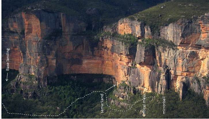
|
|||||
10:15:00 AM |
Ignore me! I got my vertical swamps mixed up. I've only once had to retreat out that way, and that was some time in the 90s before all the fancy pants sport routes got put up. Sorry! | |||||
10:26:29 AM |
Somewhere below Samarkand is Moss's pack and few cams. In a vertical swamp. The police rescue guys walked in around the base of the cliffs to help 2 guys that retreated off Hot Cali due to lightening. I think it took about 4 hours in the rain and dark. |
|||||
4:14:27 PM |
Thanks again for the information about this trail Mikl- unfortunately I had to use it over the weekend, but it worked nicely. (This time we bailed from after the traverse pitch on Hotel Cali because of wind and rain, managed to get our ropes stuck on one of the abseils, and got down in the dark. We spent the night in a shiver-bivy behind mirrorball and walked out the next morning.) And yes, it occurs to me that I am developing an uncomfortable amount of experience bailing at Pierces Pass. |
|||||
6:25:22 PM |
How was the walk-out and which 'route' did you follow? |
|||||
8:35:53 AM |
We followed your description to follow the cliffline to meet the base jumpers track, and took that trail to the tourist track up the pass. From mirrorball we hiked along the cliff past a vertical swamp and small pool for ~30m, dropped down to skirt around the base of the cliff between critical mass and smarkland, and then hiked back up to the cliffline near smarkland (small drop down and up. 20m vertical or so). Up to here there was a very faint trail. Then we dropped down a rocky gully to skirt around walls lookdown, and then hiked back up the next gully on the far side of walls lookdown (much larger down and up. 50-60m?). I think we found the base landing spot here near the cliff base, but it was only a small gap between trees. The bush in the gap was all knocked over in the direction a base jumper would enter and there was a bunch of human trash around (old socks, plastic wrappers, a broken iphone, etc, which we packed out), but it was a very small entry with little room for error. So we may have missed the main landing. From here there was a network of faint trails but nothing obvious. We bushbashed through vines and scrub down and around the base of Rigby Hill and found a big and obvious trail immediately at the base of the cliff. This was the basejumper's track and we easily took that to the tourist track and out. This hike from Mirroball to the car took 2 hours and was much easier than our previous experience dropping all the way down to the river. |
|||||
11:21:52 PM |
On 11/05/2015 Drake wrote: >Thanks again for the information about this trail Mikl- unfortunately I >had to use it over the weekend, but it worked nicely. > >(This time we bailed from after the traverse pitch on Hotel Cali because >of wind and rain, managed to get our ropes stuck on one of the abseils, >and got down in the dark. We spent the night in a shiver-bivy behind mirrorball >and walked out the next morning.) > >And yes, it occurs to me that I am developing an uncomfortable amount >of experience bailing at Pierces Pass. Sounds like an EPIC weekend! well done not calling the authorities & taking care of yourselves. Braver than some have been it seems. I don't mean to be condescending - but with the way the weather has been, checking the report the morning you go to climb Hotel Cal is essential! |
|||||
8:22:52 AM |
>>> Sounds like an EPIC weekend! well done not calling the authorities & taking care of yourselves. Braver than some have been it seems. Thanks, I guess. We had a PLB and would have used it if things got life-threatening. It was pretty miserable, but not deadly. >>> I don't mean to be condescending - but with the way the weather has been, checking the report the morning you go to climb Hotel Cal is essential! Yeah. I checked the night before and the winds were forecast to be 10-12 kph, while they turned out to be 40+ kph. I should have re-checked in the morning, but I didn't. That was my biggest mistake. |
|||||
8:28:36 AM |
Depends where you check the wind speed too. BOM is generally pretty reliable for the Katoomba forecast. Weatherzone, Elders, etc are generally good for the Blueys weather, with the exception of the winds, where they generally significantly underforecast. |
|||||
10:02:50 AM |
>>> BOM is generally pretty reliable for the Katoomba forecast. Weatherzone, Elders, etc are generally good for the Blueys weather, with the exception of the winds, where they generally significantly underforecast. Thanks ecowain- I was using wunderground, but I'll check BOM for windspeeds too from now on. |
| There are 20 messages in this topic. |
Home | Guide | Gallery | Tech Tips | Articles | Reviews | Dictionary | Forum | Links | About | Search
Chockstone Photography | Landscape Photography Australia | Australian Landscape Photography | Landscape Photos Australia
Please read the full disclaimer before using any information contained on these pages.
Australian Panoramic |
Australian Coast |
Australian Mountains |
Australian Countryside |
Australian Waterfalls |
Australian Lakes |
Australian Cities |
Australian Macro |
Australian Wildlife
Landscape Photo |
Landscape Photography |
Landscape Photography Australia |
Fine Art Photography |
Wilderness Photography |
Nature Photo |
Australian Landscape Photo |
Stock Photography Australia |
Landscape Photos |
Panoramic Photos |
Panoramic Photography Australia |
Australian Landscape Photography |
High Country Mountain Huts |
Mothers Day Gifts |
Gifts for Mothers Day |
Mothers Day Gift Ideas |
Ideas for Mothers Day |
Wedding Gift Ideas |
Christmas Gift Ideas |
Fathers Day Gifts |
Gifts for Fathers Day |
Fathers Day Gift Ideas |
Ideas for Fathers Day |
Landscape Prints |
Landscape Poster |
Limited Edition Prints |
Panoramic Photo |
Buy Posters |
Poster Prints