![]()
Sponsored By
ROCK
HARDWARE
Chockstone Photography
Australian Landscape Prints |
 Chockstone Forum - General Discussion
General Climbing Discussion
| Topic | Date | User |
| Unclimbed PNG peak? | 31-Jul-2006 At 11:27:06 PM | Tangles |
| Message | ||
Finally heres some of those pics. Firstly Mt. Sarawaged 4040m, an easy walk, scramble to the summit.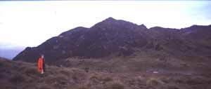 From the summit of Mt Sarawaged north to Mt. Bangietta 4120m, about 8km away. The peak is the high point to the immediate right of the distinct notch in the skyline. 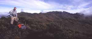 This view gives an ideas of the southern face of the Sarawaged Massif. It extends about 15-20 km like this, nearly all above 3500-3700m. 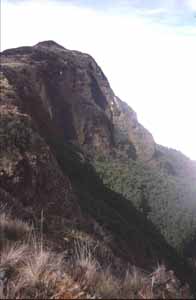 Rugged country & hard yakka to get into. Rugged country & hard yakka to get into. |
||
Home | Guide | Gallery | Tech Tips | Articles | Reviews | Dictionary | Forum | Links | About | Search
Chockstone Photography | Landscape Photography Australia | Australian Landscape Photography | Landscape Photos Australia
Please read the full disclaimer before using any information contained on these pages.
Australian Panoramic |
Australian Coast |
Australian Mountains |
Australian Countryside |
Australian Waterfalls |
Australian Lakes |
Australian Cities |
Australian Macro |
Australian Wildlife
Landscape Photo |
Landscape Photography |
Landscape Photography Australia |
Fine Art Photography |
Wilderness Photography |
Nature Photo |
Australian Landscape Photo |
Stock Photography Australia |
Landscape Photos |
Panoramic Photos |
Panoramic Photography Australia |
Australian Landscape Photography |
High Country Mountain Huts |
Mothers Day Gifts |
Gifts for Mothers Day |
Mothers Day Gift Ideas |
Ideas for Mothers Day |
Wedding Gift Ideas |
Christmas Gift Ideas |
Fathers Day Gifts |
Gifts for Fathers Day |
Fathers Day Gift Ideas |
Ideas for Fathers Day |
Landscape Prints |
Landscape Poster |
Limited Edition Prints |
Panoramic Photo |
Buy Posters |
Poster Prints