![]()
Sponsored By
ROCK
HARDWARE
Chockstone Photography
Australian Landscape Prints |
 Chockstone Forum - Crag & Route Beta
Crag & Route Beta
| Area | Location | Sub Location | Crag | Links |
| All NSW | (General) | (General) | (General) |
| Author |
|
|||||
5:32:31 PM |
Further information I posted on another thread, copied to here so as not to hijack that one... from Link 1 One of my goals is to combine more climbing with motorcycling trips ... On 13/09/2011 climberman wrote: >On 13/09/2011 SteveC wrote: > >>dragging some unsuspecting dudes out for chossy limestone adventures >in >>the Cooleman Cave gorge! > >Is there any reasonablness there ? have thought about a combined climb >/ fish trip there a few times. Looks like good camping nearby. +1 Even if it is unreasonable, I would be up for the adventure as a combined climb/ride. ~> PM sent to both of you. Some inspiration for the trip... Boulders on the way in from Tantangara towards Long Plain. 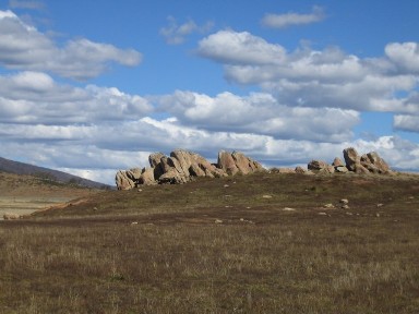 Part of the cliffs adjacent Cave Creek at Cooleman. 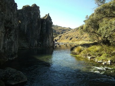 ... from ancient memory, they are bigger further downstream where the gorge narrows. Post edit 14/09/11: I remembered correctly ... 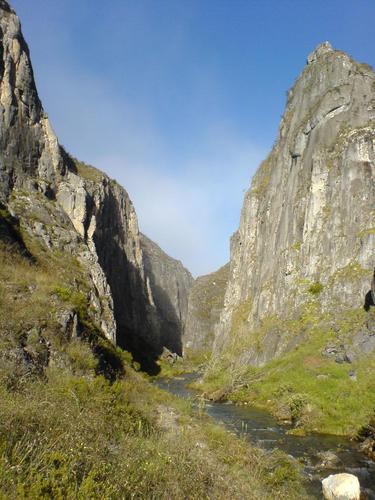 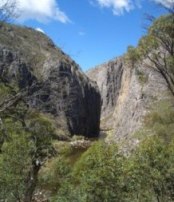 from Link 2 On 14/09/2011 Doug Bruce wrote: >Wow, great photos, especially the one of the longer stuff! Where is the >Cooleman Cave Gorge and what sort of range are the routes? > 35° 37' 25.98" S 148° 41' 30.62" E About 50 km (?) north of Adaminaby in NSW, and about half way between Yarrangobilly and Namadgi/Booroomba in a west-east direction, with an altitude of about 1200 m. Access roads (tracks really), are seasonally closed till end of Sept. by NP&WS. Routes? What routes? ~> They are yet to be done ;-) Length of the longer cliffs would be max of about two ropelengths from vague* memory, but the topouts would be rounded grassy affairs. (*I was last there in the early to mid 70's) @ uwhp510 >Does it have any gradient? For whitewater excitement? No real gradient for that unless in extreme flood event. The photos show normal flow there, however below the gorge is a waterfall that would prove interesting... |
|||||
5:40:14 PM |
(An enhanced copy of the further info from MM...) On 14/09/2011 Macciza wrote: >On 14/09/2011 IdratherbeclimbingM9 wrote: > >>Thanks for that. I recall seeing an article long ago, . . . >>;-) >> > >Thrutch No 71 June-July 1977 . >Greg Child at Wirindi on the front cover, Bob Ryan on DogFace on Editorial >page. >And of course Mike Law styling on Weirding Wall on the back . . . > >Article on Northern Snowy Mountains. >Areas aound Talbingo got developed when two Czechs Mylec & Nemec became >friends in Talbingo in the early 70's. Dveloped several areas covering >granitet, limestone and volcanics ( monolite) >Blue Water Holes Coolemon - great potential , quite close to Canberra >via backtrails across Brindabella Range. >Five known routes, though old pitons were found on some first ascents?? >Steep limestone, sustained routes; scenic nature should ensure future >popularity . . . >Nearby Yarragobilly is also talked about favourably . . . > >Hope that helps . . . > >Cheers >MM Many thanks, as that info throws a bit of light on the subject. ~> It appears I am not the first to try and track down this info, and that MM started sleuthing the Argus/Thrutch connection back in 2008 too! |
|||||
10:14:40 AM |
Can't send PMs for some reason, but we should organise a trip for october. | |||||
1:05:51 PM |
>Can't send PMs for some reason, but we should organise a trip for october. count me in too... |
|||||
1:16:16 PM |
On 15/09/2011 SteveC wrote: >Can't send PMs for some reason, but we should organise a trip for october. Mail box full? 100 posts fills it (includes both sent and received items), ... so may need clearing some? Usually if your (or receivers), mailbox is full, it tells you this when you try to send a PM. Last couple of weekends in Oct suit me better at this stage... More info. The campground at Blue Waterholes 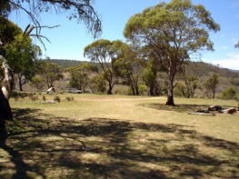 Thunderbox toilet, wood BBQ's (bring own wood), picnic tables. Don't know about water, though it has been a wet winter and the creeks will be flowing...... One of the limestone faces adjacent a cave in the area...  |
|||||
7:24:21 PM |
Ive been caving around that area and I'm pretty sure the creek below the camp area (which is on top of the hill) runs constantly...we were there in March from memory when we camped there. | |||||
10:11:15 PM |
Can't send PMs because their are retarded binary lines blowing trumpets, I can receive them well enough. I had the same problem from my work computer. 5 routes? I think we could easily double that in a weekend, I did see one old fashioned square and initials at the base of a cruisy looking crack. But no other obvious evidence of climber activity, which made me wonder whether something sinister may have occurred between the spelunkers and climbers back in the golden days. I'll make late october work. Maybe you guys PM me with emails etc? |
|||||
9:51:56 AM |
Any idea how long it would take to drive to Bluewater from southern Sydney? | |||||
9:58:33 AM |
I'd reckon on about 5hrs max . . Can i grab a lift . . . |
|||||
9:59:48 AM |
When we went there we actually went over the mountiand direct from Canberra heading south...its just over a hour that way by car from memory (maybe slightly more, it was a while ago)...we did have a run in with a local farmer who had the shits we were driving on "his property"....but it is a public road so we ignored him. The other way you drive to tumut or comma and come in the back way...looking at around 5-6 hours id say. |
|||||
10:29:30 AM |
Tempting, especially if I could put some gear in a car to save loading it all on the bike. | |||||
10:54:09 AM |
On 16/09/2011 rodw wrote: >When we went there we actually went over the mountiand direct from Canberra >heading south...its just over a hour that way by car from memory (maybe >slightly more, it was a while ago)...we did have a run in with a local >farmer who had the shits we were driving on "his property"....but it is >a public road so we ignored him. Apparently the obvious road southwards in the Brindabella valley (on West side of river) was never gazetted and council doesnt pay for maintenance. You will find locked gates and aggro this way. There are some forestry roads a bit further west (Tumut side). Check Google maps etc. But from Sydney area very likely faster via Cooma? |
|||||
11:08:24 AM |
yeah it was many years ago so they probably do lock the gates now....the farmer was very pissed....we had got to the gate that actually was the last one on his property when he suddenly overtook us in 4 wheeler bike and blocked the road and started raving about trespass etc...we off course showed the map we had that showed public access etc so honest mistake...but he wanted us to turn back.....we of course pointed out that we had 100m to go before were were off his property or we could go back the 4 or 5 km along his precious road...but he was adamant so we got in our cars and drove around him to abuse, opened the gate an went through | |||||
12:22:19 PM |
Addendum: and the roads west of Canberra (as well as straight south from Tharwa) are dirt with variable conditions: more interesting route in daytime. The route via Cooma is largely bitumen. Take care on a bike (e.g. skippies) |
|||||
2:24:29 PM |
The Mt Clear road (keep going past tharwa, then eventually turn right to Adaminaby) is dirt but its bloody good dirt. Smooth and fast. I put my old rally tyres on the datto last time I went and paddled the eucembene and it took about 50 mins from tharwa to Adaminaby in the wet. | |||||
10:17:34 PM |
On 16/09/2011 grangrump wrote: >Apparently the obvious road southwards in the Brindabella valley (on West >side of river) was never gazetted and council doesnt pay for maintenance. >You will find locked gates and aggro this way. >There are some forestry roads a bit further west (Tumut side). Check Google >maps etc. >But from Sydney area very likely faster via Cooma? From motorcycling mates, I have heard that the tracks you refer to can be pretty gnarly if wet... nm & MM, ... you blokes aren't going to skank our ambitions are you? Join us by all means, but if you go earlier please try to limit yourselves to the >'Gd 23+' style of potential new routes eh?x3 !!! ☺ TonyH; ... ~> possibly link with others coming in a car to carry your gear, so you can enjoy the ride? Something else for attendees to maybe to consider? Last time I was there we got quite wet fording the creek many times while negotiating our way downstream in the gorge, to make progress. I doubt the 'track' is any better now, but could easily be wrong. Getting wet is OK if you are prepared for it... |
|||||
11:34:05 PM |
Ummm , we were just sorting things out so we could take TonyH's gear, honest squire . . . | |||||
4:28:31 PM |
I've always liked the novelty of limestone in Australia. I'd be keen to join you guys for a weekend trip if the dates right. Looks like a fun place to just explore - both vertical and water. | |||||
4:40:33 PM |
So, after hearing about this place 10yrs ago as potential limestone climbing on Canberra's back doorstep, I finally got motivated enough yesterday to go and explore it. Myself, my mate Oli, and my brother Pete (who doesn't climb) rolled out of my place at 8ish, went the back way (Tharwa, Orroral Valley), and arrived in Adaminaby via 50ish km's of good dirt at about 9:30. There we met the Queenbeyan contingent (Macin and Baltazar) over coffee and pastries. Adaminaby has a nice little bakery and I can recommend the cherry danish. After faffing over coffee for a while, we drove the 65k's to Yarrangobilly and the turnoff onto the dirt. Here we had the misfortune to become immediately stuck behind a convoy of 6 geriatric four wheel drive morons who insisted on driving at 35km/hr on a pretty good dirt road, in their tricked out cruisers, maintaining a 20m spacing so as to maximise the ammount of dust they were breathing and make overtaking almost impossible (its always stumped me that old people drive so slow, don't they realise that they're running out of time?!) Oli finally cracked the shits and performed a series of amusing overtaking manouvers, acknowledged by much beeping of horns and flashing of lights from the old farts. We finally arrived at the Blue Waterholes campground at 11ish, I was a smidge shocked at how long it takes to get somewhere which is less than 100k's from my house as the crow flys. Anyway, I won't hold you in suspense. The place is very nice, the river which appears from underground is much larger than I was expecting, and bloody freezing. We reached the cliffs in about 15mins walk, and they are much higher than I was expecting (60m), and look very steep and spectacular. However.........its pretty bloody choss! After a rather underestimated scurry down to check the water fall and lower gorge, we returned to scope the bit in this photo (which has all the best looking walls) 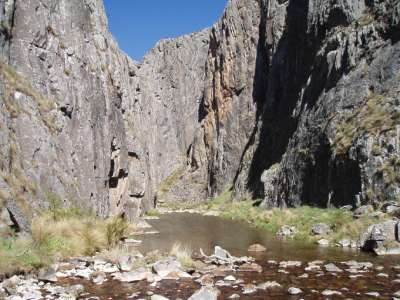 Crag at Blue Water Holes - climbing allowed!!.......but chossy and pretty shit Oli and Macin roped up to climb an old route with initials at the base (brave), I rapped into the best looking bit. Its the steep, yellow patch in the above photo (cunning), while Pete and Baltazar played with Hotwheels next to the river (best option). Results were mixed; I was a bit surprised to find a new looking stainless petzl hanger 1m from where I was trying to arrange gear for a rap (always reassuring to learn that one's idea of a good line is not completely out of whack). I was also surprised that my guess of 40m was out by half again, the rope end was off the deck. More surprise that a British couple had plonked on a rock to have lunch approx. 5m from a point directly beneath me. Not totally surprised that everything I touched was loose (I stuffed my pockets and chalkbag with bits of rock which were attempting to jump off and kill the lunching Brits). Mild surprise that there were 2 carrots and about 15 antique (but pretty good) pegs in the route, it would have been quite the adventure as a ground up ascent in the 70's........those dudes must have been able to climb! With a serious trundle, it might be ok, but I'm talking in the region hundreds of kilos of rock which needs to be launched, and it seems ethically suss to do that in a popular bushwalking spot. The route looks about 18/19 and is in the same choss-league as the very dodgiest stuff I experienced in the Doli's. Meanwhile, Oli had eschewed the lameness of abseil inspection and launched up a cornery thing with initials at the bottom. It looked fantastic from where I was hanging on the rope, but is apparently just as loose the thing I checked out, with the added bonus of dry, slippery grass choking all the cracks. Macin (our Polish mountaineering hardman mate) seconded up gingerly with shouts of "You're nuts Oli, no way would I lead this thing!" Their assessment is grade 15ish, and not really worth gardening/trundling to get it into sane climbing condition. The Hotwheels team had a great afternoon. A few photos were taken, but they're the same as the previous ones in this thread with the odd person thrown in here and there. It was nice to check the place out and see what's there, but I'm not going back for climbing. Unless you live in Adaminaby, I don't really see why you'd seek to establish new routes at chossy Blue Waterholes instead of on the good limestone at Bungonia. |
|||||
4:44:24 PM |
Thanks for eliminating that one from my list Damo. |
| There are 47 messages in this topic. |
Home | Guide | Gallery | Tech Tips | Articles | Reviews | Dictionary | Forum | Links | About | Search
Chockstone Photography | Landscape Photography Australia | Australian Landscape Photography | Landscape Photos Australia
Please read the full disclaimer before using any information contained on these pages.
Australian Panoramic |
Australian Coast |
Australian Mountains |
Australian Countryside |
Australian Waterfalls |
Australian Lakes |
Australian Cities |
Australian Macro |
Australian Wildlife
Landscape Photo |
Landscape Photography |
Landscape Photography Australia |
Fine Art Photography |
Wilderness Photography |
Nature Photo |
Australian Landscape Photo |
Stock Photography Australia |
Landscape Photos |
Panoramic Photos |
Panoramic Photography Australia |
Australian Landscape Photography |
High Country Mountain Huts |
Mothers Day Gifts |
Gifts for Mothers Day |
Mothers Day Gift Ideas |
Ideas for Mothers Day |
Wedding Gift Ideas |
Christmas Gift Ideas |
Fathers Day Gifts |
Gifts for Fathers Day |
Fathers Day Gift Ideas |
Ideas for Fathers Day |
Landscape Prints |
Landscape Poster |
Limited Edition Prints |
Panoramic Photo |
Buy Posters |
Poster Prints