![]()
Sponsored By
ROCK
HARDWARE
Chockstone Photography
Australian Landscape Prints |
 Chockstone Forum - Crag & Route Beta
Crag & Route Beta
| Area | Location | Sub Location | Crag | Links |
| International | (General) | (General) | (General) |
| Author |
|
|||||
1:13:43 AM |
Found an interesting article about rockfall in Yosemite, and it's impact on the park;) It's reported a half dozen sites from camp 4 will be closed:( http://www.sltrib.com/sltrib/world/54302568-68/park-rock-yosemite-valley.html.csp |
|||||
6:52:36 AM |
I wonder why they're closing sites at Camp 4? As far as I know it's relatively safe from a rockfall perspective - there aren't any big cliffs directly behind it. | |||||
9:04:11 AM |
I guess "relatively" is a concept relative to your POV. If the geological report they've had done suggests there is any chance of rockfall impinging on a campsite then they will close it to minimize their liability. Maybe we should the thankful that only a relatively small number of sites have been closed. | |||||
11:03:22 AM |
On 15/06/2012 Doug wrote: >I guess "relatively" is a concept relative to your POV. If the geological >report they've had done suggests there is any chance of rockfall impinging >on a campsite then they will close it to minimize their liability. Maybe >we should the thankful that only a relatively small number of sites have >been closed. "1/2 a dozen sites" seems actually quite a lot of camp 4 - there's maybe only 20-30 sites there all up? it's just that you get multiple people in multiple groups on each on each site i figure it's all the up hill side of midnight lightning boulder that are going. I guess it ends up being 30 or so people less per night in an already hard to get into camp site. |
|||||
1:47:26 PM |
Here is a post on supertaco from the geologist employed by the parks service ... http://www.supertopo.com/climbing/thread.php?topic_id=1852598&tn=40 Always good to read the original document and compare to the media reporting. Do it often enough and you'll wonder why you bother reading newspapers at all. The executive summary: after the big rockfall on glacier point a few years ago that wiped out a few shacks in curry village, the parks service employed a geologist to work out areas of highest risk from rockfall. The results of that survey have identified a few areas of risk and a few changes are in order, i.e. relocation of buildings, paths, etc. Nothing major, all sounds quite sensible. P.s. very cool pic of a boulder squashing a curry village hut in the link |
|||||
2:37:37 PM |
On 15/06/2012 Wendy wrote: >"1/2 a dozen sites" seems actually quite a lot of camp 4 - there's maybe >only 20-30 sites there all up? A few more than that; There's actually 37: 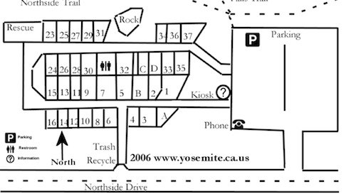 ..but you're right: it's proportionately quite a lot. The amount of camping space at that particular campground is reduced by about 16%. But what else could they do? Any perceived threat as detailed by a geologist employed specifically for the purpose of assessing potential danger would have to be acted upon. And the NPS would have been obliged to do a survey if they wanted to be sure of not being negligent given the history of rockfall, especially the 2008 event. And, in terms of the camping area lost, Camp 4 represents only a smidgen of the camping that is available in Yosemite National Park, albeit the only place within the valley itself that is available on a non-reservation basis. Of course Camp 4 does has that significance as "the" campground where climbers congregate so it is a shame that sites had to be closed but really the NPS had no alternative. |
|||||
2:51:38 PM |
On 15/06/2012 Doug wrote: >But what else >could they do? Any perceived threat as detailed by a geologist employed >specifically for the purpose of assessing potential danger would have to >be acted upon. The link you posted above makes no mention of Camp 4 or environs at all, only Glacier Pt (which I agree is a scary place - only climbed there once but it was pretty spooky to hear about the 2008 rockfall). Like I said, there are no big cliffs close to Camp 4 - in fact directly behind it is the gully / scree slope that the initial switchbacks of the Upper Yosemite Falls Trail go up. A little suspicious that they'd be closing parts of Camp 4 due to rockfall danger without also closing that (popular!) trail... |
|||||
2:57:46 PM |
Didn't the park authorities want to close camp 4 in the past? If so this could be a roundabout way of doing that under the disguise of safety? | |||||
3:15:49 PM |
On 15/06/2012 pmonks wrote: >On 15/06/2012 Doug wrote: >>But what else >>could they do? Any perceived threat as detailed by a geologist employed >>specifically for the purpose of assessing potential danger would have >to >>be acted upon. > >The link you posted above ... I didn't post the link, Stugang did. ...makes no mention of Camp 4 or environs at all, >only Glacier Pt (which I agree is a scary place - only climbed there once >but it was pretty spooky to hear about the 2008 rockfall). > >Like I said, there are no big cliffs close to Camp 4 - in fact directly >behind it is the gully / scree slope that the initial switchbacks of the >Upper Yosemite Falls Trail go up. A little suspicious that they'd be closing >parts of Camp 4 due to rockfall danger without also closing that (popular!) >trail... I don't think there is a conspiracy at work here. Direct quote from the report: "Yosemite National Park and USGS scientists, in collaboration with academic geologists, recently completed a comprehensive study of rockfall hazard and risk in Yosemite Valley. This internationally peer-reviewed study utilized new data and technologies to map the cliffs and talus slopes, date ancient rockfalls, and perform computer simulations of potential future rockfalls. This information was used to identify a rockfall hazard line on the valley floor. Existing structures within this line were evaluated using a numerical "risk metric" that quantifies the risk posed to human life and safety. This study represents the first time that rockfall risk has been quantitatively assessed in Yosemite Valley. ... ...The information in the study was adopted by Yosemite National Park this month ... And here is an image from the actual report: 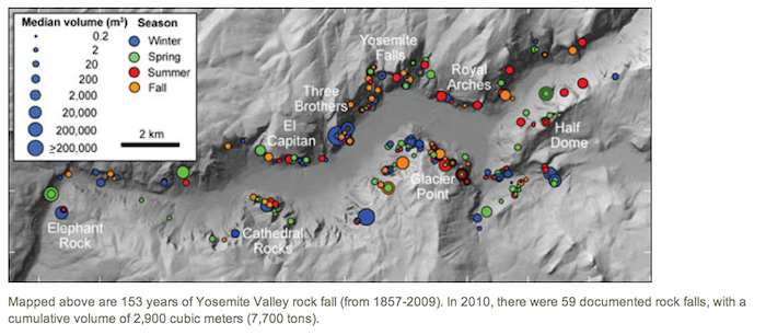 It looks like there has been considerable rock movement around Camp 4, some of which probably has resulted in the "gully/scree slope" of which you speak. (I'm not a geologist, but those who collaborated on the report clearly are in the upper echelons of that profession). One probably needs to read the full report (http://www.nps.gov/yose/naturescience/upload/Quantitative-rock-fall-hazard-and-risk-assessment-for-Yosemite-Valley-April-2012.pdf) but in the end I think unless you're a geologist you'd probably have to accept that the NPS, on the advice of expert geologists didn't really have a choice to close any areas that were concluded to be of a high risk level. In regards to leaving the trail open, I don't really have an answer for that except that maybe because it's a trail rather than the campsite the risk at any one time of someone being injured is less? |
|||||
3:26:46 PM |
On 15/06/2012 Doug wrote: > I don't think there is a conspiracy at work here. I'm with you. Can you imagine the field day had by lawyers if the geologists findings were overlooked and a person was injured/squished by a rockfall? |
|||||
4:19:47 PM |
>in the end I think unless you're a geologist you have to accept that the NPS, on the advice >of expert geologists didn't really have a choice to close any areas that were concluded to >be of a high risk level From a geology standpoint the report doesn't have any glaring inconsistencies - they've set out to map out hazard zones for rockfall, used up to date tools and techniques, and seem to have done a pretty good job. In the bit that I have actual professional expertise on, their methods and results have been pretty exhaustive (think someone toiling for six months in the lab), and have been interpreted sensibly. The hazard ranges that they've defined have been based on some pretty solid data e.g. mapping the distribution of boulders produced by rockfall (e.g. the ones actually in camp 4), and have been modified a little by results from some modelling experiments. In the case of Camp 4, the modelling actually led to the hazard being downgraded, while the opposite was the case for Curry village. So: >Didn't the park authorities want to close camp 4 in the past? If so this could be a >roundabout way of doing that under the disguise of safety? I'm not convinced that they've been overly biased against Camp 4 relative to the other campgrounds/accomodation in the valley. All we need now is to get them to model how likely it is for you to lever off that dodgy flake that looks just ready to go... |
|||||
4:25:35 PM |
You have too much faith in people Miguel. Do you really believe that site 15 is too dangerous to allow camping, but site 18 is perfectly safe? If these clowns are suggesting that the risk of being squished goes from 'unacceptable' to 'safe' in the space of 10m, they're stupid or lying or both. | |||||
5:53:47 PM |
On 15/06/2012 Doug wrote: >On 15/06/2012 Wendy wrote: >>"1/2 a dozen sites" seems actually quite a lot of camp 4 - there's maybe >>only 20-30 sites there all up? > >A few more than that; There's actually 37: > > > >..but you're right: it's proportionately quite a lot. The amount of camping >space at that particular campground is reduced by about 16%. It's proportionately a bit more as 17-22 don't exist - unless that is the already reduced campsite map? So that 6 out of 31 sites closed. In a campground that has a queue from at least 6 am to get into and is the only camping in the valley that you don't need to have booked 6 months in advance. I did learn from my last valley experience just to be organised and book something 5 months in advance - the camping is nicer, less crowded and has less hassles. I can PM anyone my valley strategy if they are organised enough to be 6 months in advance of their trip, it will be well worth it. Necessary to close sites or not, I don't know, I haven't even looked at the report, I just think the impact of the closed site will be quite noticeable. |
|||||
7:02:18 PM |
On 15/06/2012 One Day Hero wrote: >You have too much faith in people Miguel. Do you really believe that site >15 is too dangerous to allow camping, but site 18 is perfectly safe? Yup;) >If these clowns are suggesting that the risk of being squished goes from 'unacceptable' >to 'safe' in the space of 10m, they're stupid or lying or both. I buy it! Sometimes all there is between squished and safe is the distance between car seats... |
|||||
8:28:47 PM |
>On 15/06/2012 One Day Hero wrote: >You have too much faith in people Miguel. Do you really believe that site 15 is too >dangerous to allow camping, but site 18 is perfectly safe? If these clowns are suggesting >that the risk of being squished goes from 'unacceptable' to 'safe' in the space of 10m, >they're stupid or lying or both. ODH - too clever by half. Been taking lessons from denialists recently? If you read through the report it pretty clearly outlines why they made the decision. It all comes back to probability. From both the past evidence (i.e. the distribution of boulders produced by rockfall - including those in camp 4) and the modelling there was a pretty quick drop off in the amount of boulders that make it off the talus slope that runs along the norther side of camp 4 - about 40% were in the first 10 metres of the edge. Thus, it's much less likely to get a house sized mutha running right out on the road, compared to one ending up on the picnic shelter. From there it's just a matter of trying to define a recurrence interval that you're happy with. Is one squashed tent every 1000 years OK? one every 100 years? The line used by the parks service was decided on a 1 in 500 year event. More conservative than most flood based zoning systems, but given the rapidity of the hazard and high likelyhood of someone getting strawberry jammed in their sleep is probably too far off the scale for somewhere that life has value. |
|||||
8:52:16 PM |
On 15/06/2012 wombly wrote: >Is one squashed tent every 1000 years OK? one every 100 years? I'm comfortable with one every 3 years, just to keep things spicy... |
|||||
9:57:26 PM |
On 15/06/2012 Miguel75 wrote: >I'm comfortable with one every 3 years, just to keep things spicy... > Can I interest you in some recently cleared acreage in the Grampians. Many sites to choose from*, each offering innovative landscaping opportunities. *Subject to excision from National Park |
|||||
10:22:42 PM |
On 15/06/2012 Miguel75 wrote: > >I'm comfortable with one every 3 years, just to keep things spicy... Then I've got just the "secret" bivy spot at the base of El Cap for you! |
|||||
10:28:39 PM |
On 15/06/2012 Wendy wrote: >On 15/06/2012 Doug wrote: >>On 15/06/2012 Wendy wrote: >>>"1/2 a dozen sites" seems actually quite a lot of camp 4 - there's maybe >>>only 20-30 sites there all up? >> >>A few more than that; There's actually 37: >> >It's proportionately a bit more as 17-22 don't exist - unless that is >the already reduced campsite map? Well, 17 - 22 = 6 sites, so that's my guess. I did learn from my last valley experience just to be organised >and book something 5 months in advance - the camping is nicer, less crowded >and has less hassles. I can PM anyone my valley strategy if they are organised >enough to be 6 months in advance of their trip, it will be well worth it. I was going to mention that myself but thought I'd probably get howled down by certain people who post on this forum so didn't bother. But now that you have, I'll add my bit. I've spent a while camping in all three of the other campgrounds. It was far more amenable than Camp 4: you could get to sleep at night if you wanted to and the toilet blocks were actually reasonable places to visit. The North Pines campground I remember as being really nice. Here's the URL for info on camping in Yosemite: http://www.nps.gov/yose/planyourvisit/campground.htm There are also campgrounds outside the valley but not too far away where you don't have to book. And, if you are in the valley and you want to stay longer and are prepared to get up early enough to be at the campsite registration office early enough so that you are first in line, you can often get up to a week extra time. Besides all that, in 4 long stays in Yosemite, the only time I've ever got sick was one of the two times I stayed at Camp 4, and I ended up with stuff coming out of both ends for a week. It was horrible! |
|||||
6:46:44 AM |
+1 re North Pines, or really any of the camping up that end - waaaay nicer than Camp 4. The tent cabins aren't too bad either, particularly if it starts raining (the camping sites tend to fill up with water pretty quickly, since the valley floor is so flat). And of course don't forget the Hardin Flat Rd and Tioga Pass "bandit" camping spots. They're both free, relatively nice and not too far from the valley / Tuolumne. No facilities though, and you wouldn't want to leave any gear there unattended. |
| There are 33 messages in this topic. |
Home | Guide | Gallery | Tech Tips | Articles | Reviews | Dictionary | Forum | Links | About | Search
Chockstone Photography | Landscape Photography Australia | Australian Landscape Photography | Landscape Photos Australia
Please read the full disclaimer before using any information contained on these pages.
Australian Panoramic |
Australian Coast |
Australian Mountains |
Australian Countryside |
Australian Waterfalls |
Australian Lakes |
Australian Cities |
Australian Macro |
Australian Wildlife
Landscape Photo |
Landscape Photography |
Landscape Photography Australia |
Fine Art Photography |
Wilderness Photography |
Nature Photo |
Australian Landscape Photo |
Stock Photography Australia |
Landscape Photos |
Panoramic Photos |
Panoramic Photography Australia |
Australian Landscape Photography |
High Country Mountain Huts |
Mothers Day Gifts |
Gifts for Mothers Day |
Mothers Day Gift Ideas |
Ideas for Mothers Day |
Wedding Gift Ideas |
Christmas Gift Ideas |
Fathers Day Gifts |
Gifts for Fathers Day |
Fathers Day Gift Ideas |
Ideas for Fathers Day |
Landscape Prints |
Landscape Poster |
Limited Edition Prints |
Panoramic Photo |
Buy Posters |
Poster Prints