![]()
Sponsored By
ROCK
HARDWARE
Chockstone Photography
Australian Landscape Prints |
 Chockstone Forum - Crag & Route Beta
Crag & Route Beta
| Area | Location | Sub Location | Crag | Links |
| VIC Grampians | (General) | (General) | (General) | [ Grampians Guide | Images ] |
| Author |
|
|||||
7:36:45 AM |
Yeah, and wait till the Argus mini guide goes into mass production. | |||||
10:11:06 AM |
On 11/04/2012 JamesMc wrote: >Given the number of people there over Easter, erosion is sure to be a problem. > An abseil might help but is there a possibility of a different route to >the right? If it's steep but on solid rock then a fixed hand line. Don't think so but I'll check it out. I'm not a fan of fixed hand-lines. I have thought of sawing steps into the big log lying up against the left edge of the chockstone. |
|||||
9:35:40 PM |
Checked out the left-hand side of the chockstone for access today with a pack and it was fine. Probably marginally harder than tunnelling under the chockstone but less grotty and pretty safe. Put in an abseil anchor at the left end of the ledge so people don't have to scramble back down past the chockstone. Hopefully that'll reduce the traffic load on the eroding hillside above the chockstone. |
|||||
7:42:43 PM |
Nice work - such actions are rarely acknowledged but always appreciated by the masses. How's the port-a-loo coming along? Alex |
|||||
9:22:17 PM |
I also travelled the full length of Matthews Track this time. The western half has a couple of deepish sandy spots that would challenge a 2wd. It also has some deep bog-holes which would be diabolical in wet weather. This track is seasonally closed in any case so this shouldn't present much of a problem. But the eastern end of the track up until below Emu's Foot and for about a km further on is pretty good for 2WD. So if you're coming from Halls Gap it's a faster overall approach to Weirs Creek. It's also a viable approach to Red Sail, Gondwanaland and Eureka if Yanganaginj Njawi Track is unavailable. I'll try over the weekend to create a map to show the options. |
|||||
2:02:46 PM |
I went into Weirs Creek a few months ago approaching from the east as per Kieran's recommendation . We parked at the Zag just after the Zig and walked in from there. On Google maps you can see that the Zig Zag is because there used to be a road crossing Matthew Track, the remains are not entirely over grown and make for an easy to follow and direct walk through to Yanganaginj Njawi Track. | |||||
9:43:55 AM |
Good work on the rap Keiran, will definitely help with erosion above the chockstone / cave / tunnel. | |||||
12:32:58 PM |
Red Rocks Road closure. Matthews Track also included. This will make access to Weirs Creek not possible for the next week and a half or so. http://cliffcare.org.au/2014/05/08/red-rocks-road-closure-5514-approx-2-weeks-weirs-creek-access/ | |||||
7:51:05 PM |
The east end of Matthews Track was still open today but could change at any time. However Weir's Creek can still be approached on foot in about 50 minutes as long as the Glenelg River is not flowing, which it isn't at the moment. Park on Forest Lodge road at the gate on Hynes Track. Follow Hynes track south until it ends at the channel. Cross the channel and straight across the service track to the overgrown track running south-west. Follow this towards Emu's foot, dog-legging through the hopefully dry Glenelg River and on to meet Matthew's track at the zig. Continue along this until it zags to the right. It's about 25 minutes to here. Now head cross-country towards the landslide to meet the old track just before Weir's Creek. 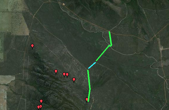 The blue bit is the section shared with Matthews Track |
| There are 49 messages in this topic. |
Home | Guide | Gallery | Tech Tips | Articles | Reviews | Dictionary | Forum | Links | About | Search
Chockstone Photography | Landscape Photography Australia | Australian Landscape Photography | Landscape Photos Australia
Please read the full disclaimer before using any information contained on these pages.
Australian Panoramic |
Australian Coast |
Australian Mountains |
Australian Countryside |
Australian Waterfalls |
Australian Lakes |
Australian Cities |
Australian Macro |
Australian Wildlife
Landscape Photo |
Landscape Photography |
Landscape Photography Australia |
Fine Art Photography |
Wilderness Photography |
Nature Photo |
Australian Landscape Photo |
Stock Photography Australia |
Landscape Photos |
Panoramic Photos |
Panoramic Photography Australia |
Australian Landscape Photography |
High Country Mountain Huts |
Mothers Day Gifts |
Gifts for Mothers Day |
Mothers Day Gift Ideas |
Ideas for Mothers Day |
Wedding Gift Ideas |
Christmas Gift Ideas |
Fathers Day Gifts |
Gifts for Fathers Day |
Fathers Day Gift Ideas |
Ideas for Fathers Day |
Landscape Prints |
Landscape Poster |
Limited Edition Prints |
Panoramic Photo |
Buy Posters |
Poster Prints