![]()
Sponsored By
ROCK
HARDWARE
Chockstone Photography
Australian Landscape Prints |
 Chockstone Forum - Crag & Route Beta
Crag & Route Beta
| Area | Location | Sub Location | Crag | Links |
| VIC Grampians | (General) | (General) | (General) | [ Grampians Guide | Images ] |
| Author |
|
|||||
9:51:47 PM |
Thanks Tracey | |||||
10:30:07 PM |
Here's a link to some photos of road damage from rain in Victoria VicRoads Facebook Photos Photos 14 to 18 are Gramps JamesMc |
|||||
2:10:21 PM |
Quick update on progress on damage assessment in the Vic Range: Parks Vic are currently working on road access into critical infrastructure so at this point in time have still not looked at many areas in the Victoria Range including the Goat Track. The last report was that the Fortress walk, Billiamina, Hut Creek area, Victoria Range Track and Goat track are badly damaged. Hopefully they will have more of an idea in the next month when they have looked at more areas. Have a new overall update which I will get around to putting up later but basically - it's the same as last. So Summerday, Stapylton and surrounds look like the main place to climb Cheers, Tracey |
|||||
2:46:15 PM |
We'll have to resort to getting to Millenium Caves by chopper! | |||||
11:51:30 AM |
On 9/02/2011 climbingjac wrote: >We'll have to resort to getting to Millenium Caves by chopper! When you organize that chopper Jacqui can you let me know and I might borrow it for a bit - I have some rocks to move up the Pharos Gully :) Hi All, Latest update and you can access the colour coded map from the vcc website here - http://www.vicclimb.org.au/index.php?location=downloads Grampians Update - Thursday 10 February 2011 New openings include the Roses Gap Road and Troopers Creek campground. Parks Victoria is working towards opening further walks and visitor sites by the long weekend in March and again in April for the Easter weekend. These openings will include some visitor sites and walking tracks on the western side of the Grampians. WHAT’S OPEN Walking Tracks Walks near Halls Gap Boronia Peak, Chatauqua Peak (east side only), Clematis Falls and the Fyans Creek Loop. Northern Grampians Hollow Mountain, Flat Rock to Mt Stapylton, Mt Stapylton Loop, Mt Zero, Heatherlie Quarry, Beehive Falls, Briggs Bluff, Gulgurn Manja and Ngamadjidj Shelters. Southern Grampians Mt Sturgeon and the Piccaninny Campgrounds Open Plantation, Troopers Creek and *Stapylton Campgrounds. * Please note that access to Stapylton Campground is via Plantation Road from Northern Grampians Road. Also: private campgrounds surrounding the Park. Roads Open • Main roads into Halls Gap and Wartook • Grampians Road to Lake Bellfield Picnic Area • Mt Zero Road (Halls Gap to Mt Zero) • Plantation Road • Flat Rock Road • Roses Gap Road Please take care in these open areas While walking tracks and roads in the above areas will be open, visitors are advised that the maintenance standard may be less than normal or expected. Park staff have taken much care to ensure that risk issues have been minimised, however hazards may still be present and visitors are advised to proceed with caution. Roads may appear in reasonable condition, but many have corrugations, soft edges and are still very wet. Please be cautious around road edges and drive slowly. WHAT’S CLOSED There is widespread damage throughout the park that includes unstable boulders, soil and trees. Park staff and Vicroads are working hard to assess the damage. It is important that visitors stay away from these areas as they remain very unstable and could move again, especially after further rain. Access roads and the wider gravel road network are severely damaged. These roads are expected to remain closed for some time. Road Closures • Northern Grampians Road (Mt Victory Road) from Halls Gap to Wartook • Grampians Tourist Road (Lake Bellfield Picnic Area to Dunkeld) • Silverband Road • All seasonal roads in the Northern Grampians • Pohlner Road (Roses Gap Road - Northern Grampians Road) • Pohlner Link Track (Pohlner Road - Mt Zero Picnic Area) • Coppermine Track Walking Track and Site Closures • All Wonderland walks (including Venus Baths and the Pinnacle) • Mackenzie Falls Walks and Zumstein Area • Balconies and Reeds Lookout • All walks in the Victoria Valley, Victoria Range (Western Grampians), Mt William Range, Mafeking and Mt Abrupt. • Mt Difficult and Tilwinda Falls walking tracks • All remote overnight hikes in the Grampians National Park (including the Mt Difficult, Major Mitchell Plateau, Fortress & Wonderland hikes) Campground Closures Jimmy Creek, Wannon Crossing, Borough Huts, Boreang, Buandik, Strachans, Smiths Mill and Bomjinna Campgrounds. Cheers, Tracey |
|||||
2:45:01 PM |
I'm hoping Tracey has some sort of update on this. Parks have just posted their "Update" on road closures in the Grampians. Well, they've changed the date but none of the words. There seems to be a parallel universe here. Last weekend I drove on tracks that appeared to be open in the southern grampians (Red Rock road loop from Henty Highway and back over Glenisla crossing). The roads appeared undamaged apart from fallen trees which had been cleared. According to today's update these roads are still closed because they're dangerous. Give me a break. Parks are creating dangerous precedents for themselves here. If these areas aren't "safe" to open, they are saying that they will be safe when opened. Well they won't be. Trees will still fall and idiots will still drive too fast on rough roads. |
|||||
3:00:35 PM |
So you admit to driving on a road that is legally closed to the public. If the PV update has only changed the date it is because all the roads are still closed. PV are focussing their limited staff and dollars on high profile areas. Yes trees will fall etc, but they have to manage a bad situation the best way possible. Meanwhile, the Public Sector continues to conspire against rock climbers access as much as possible............... |
|||||
3:10:18 PM |
if they don't have road closed signs at the start, how are we to know the roads are closed? Not everyone has the internet. Not everyone would even know to look to see if there was a road issue. I imagine there are still climbers who don't haunt Chockstone that arrive from interstate expecting to climb in the gramps and just go off road closed signs in place. | |||||
3:27:05 PM |
On 25/02/2011 STEALTH wrote: >So you admit to driving on a road that is legally closed to the public. >If the PV update has only changed the date it is because all the roads >are still closed. The roads may have been legally closed but there was nothing to indicate that until I reached the end. >PV are focussing their limited staff and dollars on high profile areas. The weird thing is that they've obviously done a lot of work in these areas. It wouldn't take a little more effort to actually tell us what's happening and why the closures are still in place. There doesn't appear to be any reason why the public should be stopped from visiting Red rock Picnic Area. >Yes trees will fall etc, but they have to manage a bad situation the best >way possible. There didn't appear to be a bad situation on the roads I travelled. It's seems strange to have fixed them but keep them closed. >Meanwhile, the Public Sector continues to conspire against rock climbers access as much as possible If there's a good reason to close it, fine. There are roads that are badly damaged and I don't have a problem with it. But forget about us climbers; if i was a tourist provider around Wartook i would be spitting chips that there are safe areas that are being kept closed.. |
|||||
3:35:24 PM |
Having driven most of the Grampians since the big rain in my work role, I have not encountered any access points that do not have road closed signs or gates across them. Rather than whingeing here why not contact the Ranger in Charge in the Grampians? Physically driving a road does not mean there are unseen issues that may keep the roads closed. In ther ecently immortalised words of Tony Abbott "Sh*t Happens". There are plenty of climbing areas still accessible. |
|||||
3:40:22 PM |
On 25/02/2011 STEALTH wrote: >Having driven most of the Grampians since the big rain in my work role, >I have not encountered any access points that do not have road closed signs >or gates across them. > Are you implying that I'm lying? The access from the Henty Highway near Glenisla station had no gates or signs when I went through it last Sunday. It had previously had signage so I assumed it was open. |
|||||
3:43:03 PM |
On 25/02/2011 STEALTH wrote: >Rather than whingeing here why not contact the Ranger in Charge in the >Grampians? Direct approaches have received bland bureaucratese responses. Tracey seems able to get more information. I'm starting to calm down now. |
|||||
3:43:04 PM |
read my message properly. | |||||
3:44:21 PM |
On 25/02/2011 kieranl wrote: (snip) >The weird thing is that they've obviously done a lot of work in these >areas. It wouldn't take a little more effort to actually tell us what's >happening and why the closures are still in place. There doesn't appear >to be any reason why the public should be stopped from visiting Red rock >Picnic Area. They have contacted me to explain the current situation and attend the meeting and to pass the information on to the climbing community. The meeting was on Tuesday and as much as I wanted to get my notes typed up immediately and before the weekend, my other work commitments haven't allowed. They will be up on the weekend with the current progress report. Meanwhile the downloadable map will alert you to the roads open. As a quick add with no further explanation until later, the Vic Range is targetted to be open by Easter. |
|||||
4:02:05 PM |
On 25/02/2011 STEALTH wrote: >read my message properly. Which part of which message am I misreading? |
|||||
11:10:10 PM |
On Tuesday 24th February, I attended two meetings to get updates on the current and future situation of the Grampians National Park due to the recent floodings and, because of that, the ensuing landslides. I had a brief discussion with David Roberts, the Head Ranger at the Halls Gap Office before the main stakeholder meeting. I had previously organized a meeting with David late last year before the flooding to discuss climbing issues in the Grampians but, as you can imagine, due to the recent events, much of that talk has been pushed to a later date. Instead we discussed what effect the events have had on the climbing areas, or to be more specific – access to them. What impact the climbing areas have suffered will become apparent when we can actually get in. The closures at the present time are more to do with the road closures and damage. What is a definite is that there have been a large number of landslides throughout the park and from aerial view and photographs some of the climbing areas can be seen to have been impacted by this. David showed me a large satellite ‘rapideye’ photograph that amongst other things showed all the landslips across the park. Well, that is, landslips that are more than 5 metres wide. 192 of them! The other smaller ones slip under the radar so to speak. Rosea appears to have 3 large ones that intersect the track. The Fortress track has suffered badly and where sections do remain has been completely realigned. And the list goes on. Vicroads have a massive job ahead of them and in the case of Silverband Road from Sundial area down the timeline is ‘long term’. New waterways have now been created because of these landslides – this will require the engineering of the road to take into account where new bridges, culverts and crossings will be required. (c)ont |
|||||
11:11:01 PM |
cont) What I have tried to do here is to outline some very, very basic timelines and processes that may help people to understand why access, especially to some areas may be off the cards for a while. And this is still very early days yet. What we are also dealing with here is only the access, primarily road, that allows us to get there. Once this has been established, we will be able to then assess the areas themselves as to any changes that may have occurred. Rosea, from the sky, appears to have 3 landslips crossing the track. Bundaleer from a distance appears to have lost much of its vegetation on one side – again most likely due to a landslide. VicRoads are currently assessing( geotech and hydraulic assessments), clearing debris and relocating it and repairing the following roads: Grampians Road North Grampian Road Mt Victory Road Silverband Road Some of the debris has been cleared – to the sides of road. It will now need to be ‘put somewhere’. Not so easy with that much debris. One of the priority jobs for both VicRoads and PV has been to clear and make access routes through the damaged roads and areas so that critical infrastructure such as the telecommunications tower on Mt William is accessible, emergency roads for emergency crews in case of fire(this is high season), trucks and equipment for the repair work. These are clearways that need to made before any kind of access can be made available to the public. Some of these are just wide enough for a truck. As you can imagine, those areas that were hit the least have been the first to be opened. The plan is for a staged reopening - with the Western side of the park and road networks up and running first due to the least damage. North Grampians and in particular the Mount Zero areas have had repairs done and are now open for business. Summerday Valley has had new steps put in along a lot of the track. Needed it before the waters came but with a few smaller landslides along the track and loss of track covering, imperative now. The roads into the area previously graded once a month are now about twice a week to handle the heavier traffic it is now receiving. Vic Range area – Red Rocks, Buandik etc. Work on this is taking place - PV are hoping that this will be possible Easter opening. Again not as badly affected as other parts of the Gramps so being worked on presently. Working on fixing up Harrop Track. Goat Track etc Asses Ears, Wallaby Rocks area – targeted for Easter Rosea, Bundaleer area – possibility that access into the top of Silverband Rd might happen in 6 months. This is dependant on factors such as the Mt Victory Road repair. The Mt Victory Rd still has huge amounts of debris to remove, road repairs to be done. The more worrying factor is the very unstable ground above and below the road in a few particularly bad sections. This will have further geotech and hydraulic assessments carried out and more than likely specialists will need to be brought in to determine the likelihood of rockfall and then how to contain the roadsides. If this road access into the area does happen, then there is a good chance that we might be able to access Rosea and assess any work that may be required there. Highly likely the track will require work – as noted 3 large landslides(one under Tourist Buttress) have occurred at Rosea crossing the track area. The Head Ranger is keen for us to be involved once road access is established. So possibly towards end of year. The Fortress – track is almost completely destroyed. 6-12 months. Ranger keen to have climbers onboard in helping with the new track and hikers campground. This will be a totally new realignment of the track as there are now new waterways which will shape the realignment. VCC to be involved in redoing this. Will upload a few photos over the weekend that I took on the day and a few that John Stone took when he came in from the other end via Mt victory . But in the meantime you can check them out on the cliffcare smugmug site. http://vicclimbingclub-cliffcare.smugmug.com/ There are also a few brief videos at the major landslide area and walking up it.Keep checking on this site also for more photo updates and progress along with www.cliffcare.vicclimb.org.au Cheers, Tracey |
|||||
9:20:26 PM |
New improved access to Mt Abrupt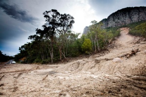 JamesMc |
|||||
10:08:16 PM |
Just to show that we're all not just bitching about the closed roads, below are before and after shots of recent activities of the Grampians Chainsaw Fairies.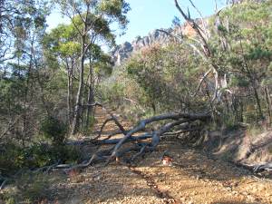 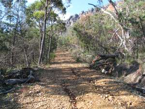 |
|||||
8:57:45 AM |
Any news on the access to red rock rd area crags? |
| There are 143 messages in this topic. |
Home | Guide | Gallery | Tech Tips | Articles | Reviews | Dictionary | Forum | Links | About | Search
Chockstone Photography | Landscape Photography Australia | Australian Landscape Photography | Landscape Photos Australia
Please read the full disclaimer before using any information contained on these pages.
Australian Panoramic |
Australian Coast |
Australian Mountains |
Australian Countryside |
Australian Waterfalls |
Australian Lakes |
Australian Cities |
Australian Macro |
Australian Wildlife
Landscape Photo |
Landscape Photography |
Landscape Photography Australia |
Fine Art Photography |
Wilderness Photography |
Nature Photo |
Australian Landscape Photo |
Stock Photography Australia |
Landscape Photos |
Panoramic Photos |
Panoramic Photography Australia |
Australian Landscape Photography |
High Country Mountain Huts |
Mothers Day Gifts |
Gifts for Mothers Day |
Mothers Day Gift Ideas |
Ideas for Mothers Day |
Wedding Gift Ideas |
Christmas Gift Ideas |
Fathers Day Gifts |
Gifts for Fathers Day |
Fathers Day Gift Ideas |
Ideas for Fathers Day |
Landscape Prints |
Landscape Poster |
Limited Edition Prints |
Panoramic Photo |
Buy Posters |
Poster Prints