![]()
Sponsored By
ROCK
HARDWARE
Chockstone Photography
Australian Landscape Prints |
 Chockstone Forum - Crag & Route Beta
Crag & Route Beta
| Area | Location | Sub Location | Crag | Links |
| VIC Grampians | Central | (General) | (General) | [ Grampians Guide | Images ] |
| Author |
|
|||||
7:27:57 AM |
Hi, I'm hoping to be able to get some help to better describe the access to the Asses Ears using GPS Points of Interest and a good map. Does anyone have "points of interest" (Longitude and Lattitude) GPS data for: 1: The corner of Mt Victory road and the Asses Ears road 2: The car park for the Asses Ears 3: The base of the main wall Here is the map we're going to be putting this info onto - which will be part of the new "Sublime Climbs - a select guide to climbing in Victoria". 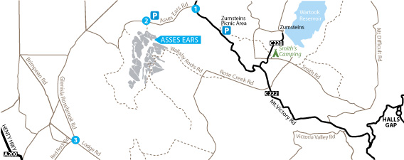 Regards, Josef & the team at Rockmaster Publications http://www.rockmaster.com.au/ |
|||||
8:25:01 AM |
Why don't you just get them off Google Earth? | |||||
11:32:20 AM |
You could also look at the DSE website, interactive mapping. They will show walking and 4WD tracks. | |||||
11:45:06 AM |
>1: The corner of Mt Victory road and the Asses Ears road -37.0766 142.3660 >2: The car park for the Asses Ears -37.0870 142.3293 >3: The base of the main wall -37.0928 142.3310 Taken from Google Earth. |
|||||
7:38:46 AM |
Thanks all. Steve - do you have a link for that DSE site you're talking about? Sounds worth checking out. PS Does anyone know if this standard we've been using is OK, or if there is a better (different format) way to show the points of interest: Smith's Mill Camp S37 06.506 E142 25.421 |
|||||
8:52:23 AM |
www.dse.vic.gov.au on right hand side is "INTERACIVE MAPS" use forest explorer or biodiversity interactive maps. They are good tools for making maps for your particular walk, crag etc. |
|||||
11:07:39 AM |
These maps are brilliant. Why didn't I find this before? |
| There are 7 messages in this topic. |
Home | Guide | Gallery | Tech Tips | Articles | Reviews | Dictionary | Forum | Links | About | Search
Chockstone Photography | Landscape Photography Australia | Australian Landscape Photography | Landscape Photos Australia
Please read the full disclaimer before using any information contained on these pages.
Australian Panoramic |
Australian Coast |
Australian Mountains |
Australian Countryside |
Australian Waterfalls |
Australian Lakes |
Australian Cities |
Australian Macro |
Australian Wildlife
Landscape Photo |
Landscape Photography |
Landscape Photography Australia |
Fine Art Photography |
Wilderness Photography |
Nature Photo |
Australian Landscape Photo |
Stock Photography Australia |
Landscape Photos |
Panoramic Photos |
Panoramic Photography Australia |
Australian Landscape Photography |
High Country Mountain Huts |
Mothers Day Gifts |
Gifts for Mothers Day |
Mothers Day Gift Ideas |
Ideas for Mothers Day |
Wedding Gift Ideas |
Christmas Gift Ideas |
Fathers Day Gifts |
Gifts for Fathers Day |
Fathers Day Gift Ideas |
Ideas for Fathers Day |
Landscape Prints |
Landscape Poster |
Limited Edition Prints |
Panoramic Photo |
Buy Posters |
Poster Prints