![]()
Sponsored By
ROCK
HARDWARE
Chockstone Photography
Australian Landscape Prints |
 Chockstone Forum - General Discussion
General Climbing Discussion
| Author |
|
|||||
2:45:02 PM |
Hi, as part of the new "Best of Victoria" guidebook, we will be posting a free file (in various file formats) for travelling climbers to more easily find their way around on our website. I've been gathering this information in person for some time now. The file I've got also includes some points of interest in NSW and Tassie, although it's only comprehensive (as far as the areas covered in our guide at least) for Victoria. I am hoping that some kind climbing folk who own a GPS can try uploading my data file and test the method that I think will help so much. I do have a little story of a certain couple traversing the Dolomites in Italy some years ago and struggling to find their way around and getting serious cranky pants (no we didn't have a GPS at the time). So my motivation and intention is to try and alleviate this tension with any climbing couples travelling to Victoria in the future who can be bothered to upload a file to their GPS. On this file will be: - camp sites - car park locations - some cliff locations I hope that it will be very useful for those wanting to use this technology. In our guidebook will be - clear maps showing the GPS locations for car parks, camp sites and some cliffs. So down to it... if you own, or have access to a GPS I'd love to hear from you, and prove the method for file sharing this data I've been putting together. Please get in touch with me and request the file via jgoding@aanet.com.au I have a Garmin Nuvi 500 (which I'm very happy with) and a bit of software that came with it called "Map Source", so you can see all your points of interest on the computer, not just the GPS itself. You can easily edit them and also save the file in a few other file formats, including - Garmin database format 2 (.gdb) - Garmin database format 3 (.gdb) - mps files (.mps) - tab delimited (.txt) - DXF (.dxf) - GPS eXchange Format (.gpx) I'm hoping that we can prove file sharing across different platforms (brands) and models of GPS succesfully. Hopefully this process won't prove to be too much of a hassle, and be outweighed by having a good amount of quality, proven information. You should be able to then simply search for "Arapiles" and see listings for "The Pines Campsite", or "Hollow Mountain Car Park", Mt Rosea, or Bundaleer just to name a few. Righto - over to those techky climbing folk to work your magic (I hope!) and prove my theory! Regards, Josef, Rockmaster Publications www.rockmaster.com.au |
|||||
4:24:05 PM |
Do you have a URL you can share? Because apps like "Trails" for the iPhone like to grab their GPX files from a web hosted URL. So if you can supply one of those I'm happy to test it on my iPhone. Cheers. |
|||||
4:31:20 PM |
Howdy, no URL as yet - we want to trial the method before we go promoting it widely. Happy to e-mail you the file however. |
|||||
4:34:34 PM |
OK check just emailed ya. | |||||
6:02:49 PM |
A list of eastings and northings would be simpler and universal, but not as fancy. It would allow people with gps phones that don't load Garmin etc... software to still locate. | |||||
8:31:54 PM |
GPX file format is pretty universal and works great in Google Earth to name one of many apps. Lot easier then adding in by hand a lot of eastings and northings. | |||||
7:40:51 PM |
Hey Fish Boy, in the guide the maps have GPS points on them, like this: 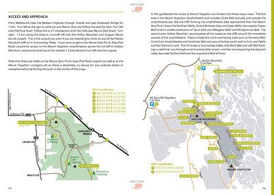 and thanks to those who have offered to help test this file. So far we are working on testing: - Android (Google/Nexus phone) - Garmin Oregon 300 GPS - IPad (was succesful with the .GPX file) - IPhone It would be great if anyone has a Tom Tom or Magellean unit if they could get in touch, as this will really prove that this file can be useful across many different brands and models. |
|||||
7:38:52 AM |
I do lots and lots of gps stuff professionally and for fun. I have found, at the moment, that Google kml files are the easiest for sharing. I think this will surpass gpx if it hasn't already. It also gives folk the chance to preview the stuff on their computer if they have not paid for any maps with their gps. Also works for windows, mac, linux, android, iphone etc... I did this recently for the Wild Endurance race in the Blue Mountains: http://www.wildendurance.org.au/index.php?sectionID=11991&pageID=12063 Richard |
|||||
8:14:55 AM |
Another big round of support for use of a google maps file. Use them for work and play all the time, very easy to share, small size, access to virtually everyone, can add forkloads of info. Richard - that's one mother-truckin ugly course ! |
|||||
10:09:07 AM |
On 28/01/2011 jgoding wrote: >Hey Fish Boy, in the guide the maps have GPS points on them > >and thanks to those who have offered to help test this file. So far we >are working on testing: > >- Android (Google/Nexus phone) >- Garmin Oregon 300 GPS >- IPad (was succesful with the .GPX file) >- IPhone > >It would be great if anyone has a Tom Tom or Magellean unit if they could >get in touch, as this will really prove that this file can be useful across >many different brands and models. I own and regulary use a magellen gps for work and play, if you would like someone to test out the gps files on a magellen I would be happy to. Paul |
|||||
1:12:57 PM |
Hi Rich, wow - great idea with Google Earth. The link/file you've posted on that site is easy to use, clear and excellent! I'd love it if we could do something similar with our file for Victorian climbing point of interests. Have just shot you off our latest file for a look. Paul - thanks for offering to help test our file on your Majellean Explorist GPS, and confirming just now that it was succesful. PS James McIntosh has kindly proven a succesful upload (using the Garmin software "Mapsource") of this file to his Garmin Etrex Vista HCx GPS. Thanks again everyone for helping out with this! |
|||||
12:56:01 PM |
Bump! Still hoping someone can help me sort out how to share this GPS file on to an IPHONE! All other platforms seem to be succesful which is great. |
|||||
9:11:16 PM |
Have a look at OpenStreetMap Uploading the data to there would provide additional value and there will already be data in it for a lot of stuff. eg. it already has Centenary Park Campground, Hollow Mountain Carpark, Stapylton Campground. For those unfamiliar, OSM is a free editable map of the world. Inspired by wiki-style editable sites such as Wikipedia. http://en.wikipedia.org/wiki/OpenStreetMap http://openstreetmap.org |
|||||
10:37:04 PM |
Google maps on iphones can load kml files from URLs - you just need to save your kml or kmz to a site somewhere. Again, the Wild Endurance stuff discussed earlier is an example. If reading this thread on an iPhone then click on the link: http://maps.google.com.au/maps?f=q&source=s_q&hl=en&geocode=&q=http://www.epacrisenviro.com.au/WE2011/Wild-Endurance-2011.kmz&sll=-33.714898,150.322967&sspn=0.017527,0.032938&ie=UTF8&t=h&z=13 Works fine on my old iPhone 3G - but a bit slowly... Another way is to enter http://www.epacrisenviro.com.au/WE2011/Wild-Endurance-2011.kmz into the Google Maps search box and it will load up. At the moment, the Google Maps app only supports points and tags are ignored (not lines) but this is a very speedy way to load datasts. Richard |
|||||
9:27:38 AM |
>Still hoping someone can help me sort out how to share this GPS file on >to an IPHONE! GPX file works fine on the iPhone. I've tested it. A bit messy, I still think you will need to break down the points by region instead of having them all in one file. But Google Earth can help here. Just load the GPX file into that app and then you should be able to output KML files for regions/sets. Also the best apps for GPX/KML data on the iphone/ipad are GPSKit and Motion X which both cost money. But I've found them pretty good and faster then the free apps out there for handling large data sets. Cheers. |
|||||
12:50:18 PM |
Hi, we've just added this page: http://rockmaster.com.au/index.php/gps-file-sharing.html enjoy - and any feedback most welcome. |
|||||
4:12:30 PM |
Works great for me. (Android) I logged into google maps on my PC and added the .kmz file from the url as a 'my map'. POI are now available as a layer under 'my maps' on google maps on my phone. |
|||||
9:46:12 PM |
Excellent to hear - thanks for trying it out. | |||||
1:45:16 PM |
Bump... has anyone else tried using this file? I've recently transferred (in person from my laptop) this file to Rob Booth and Steve Toal. Be nice if all this hard work could be made use of now that Sublime Climbs is out. I hope all of you who purchased Sublime Climbs and who have a GPS can have a go at downloading this file from our website and upload it to your GPS! |
|||||
7:21:37 AM |
I use (free) Shonky maps on my GPS. It covers the whole of Oz and works very well. It's been a while since I've played with the software though ... I just use the topos on my GPS. Are your files readily compatible ? http://shonkylogic.net/shonkymaps/ |
| There are 21 messages in this topic. |
Home | Guide | Gallery | Tech Tips | Articles | Reviews | Dictionary | Forum | Links | About | Search
Chockstone Photography | Landscape Photography Australia | Australian Landscape Photography | Landscape Photos Australia
Please read the full disclaimer before using any information contained on these pages.
Australian Panoramic |
Australian Coast |
Australian Mountains |
Australian Countryside |
Australian Waterfalls |
Australian Lakes |
Australian Cities |
Australian Macro |
Australian Wildlife
Landscape Photo |
Landscape Photography |
Landscape Photography Australia |
Fine Art Photography |
Wilderness Photography |
Nature Photo |
Australian Landscape Photo |
Stock Photography Australia |
Landscape Photos |
Panoramic Photos |
Panoramic Photography Australia |
Australian Landscape Photography |
High Country Mountain Huts |
Mothers Day Gifts |
Gifts for Mothers Day |
Mothers Day Gift Ideas |
Ideas for Mothers Day |
Wedding Gift Ideas |
Christmas Gift Ideas |
Fathers Day Gifts |
Gifts for Fathers Day |
Fathers Day Gift Ideas |
Ideas for Fathers Day |
Landscape Prints |
Landscape Poster |
Limited Edition Prints |
Panoramic Photo |
Buy Posters |
Poster Prints